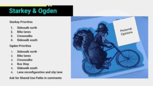
A Better Tanglewood Mall? Now is the time to weigh in on proposals for Starkey and Ogden

Quick Feedback
Quick Feedback

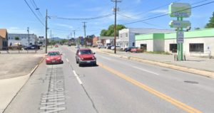
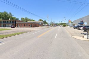
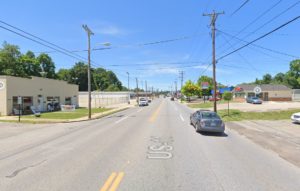
Roanoke County is soliciting feedback on proposals for bicycle and pedestrian improvements on Starkey and Ogden Roads adjacent to Tanglewood Mall. The Tanglewood Mall area has a long-term plan to be redeveloped as 419 Town Center, which includes improving the bicycle and pedestrian access and experience in the surrounding area.

There’s no sugar coating that it is currently very difficult to walk or bike to Tanglewood Mall. I have biked nearly 80% of the roads in the City of Roanoke and hundreds of miles in the surrounding area, but I have not yet chosen to bike to Tanglewood Mall. The closest I have gotten is the Roanoke city side of the 220 interchange where the bike lanes give way to sharrows while you go under 220 and the end of Winding Way Road where it intersects with Ogden Road. The intersection of Winding Way Road and Ogden Road is about .2 miles and 220 is about .7 miles from the project area of this public comment opportunity.

Roanoke County is asking for comments on their proposal and they way they are accepting comments has three major components:

  1. Ranking a list of potential improvements for Starkey road
  2. Ranking a list of potential improvement for Ogden road
  3. An open-ended comment box

Here is how I approached and answered those options. Roanoke County is accepting comments until March 15th.

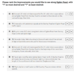
Ranking a list of potential improvements for Starkey road

The section of Starkey Road in this project area is a short section that connects two higher volume roads on either side. It has a major destination in a shopping center anchored by Food Lion, with several restaurants such as Ben Gui Sushi and Bellacino’s that I think are worth the visit to this area. From what I can tell, all of the immediately adjacent development to Starkey Road is commercial development.

There are four options provided to rank and here they are listed in the order that I ranked them:

  1. Sidewalk with landscaped buffer on north side of Starkey Road wherever space allows
  2. Bicycle lanes along both sides of Starkey Road
  3. Crosswalks at Starkey Road and Fallowater Lane
  4. Sidewalk on south side of Starkey Road

I think the sidewalk on the north side of Starkey Road is the biggest proposed improvement on Starkey Road. Providing an ideally continuous sidewalk on one side of Starkey Road would transform the safety and ability of walking along this corridor. It would make walking a viable option where it currently is not.

The bicycle lanes proposed would be consistent with the existence of bicycle lanes on surrounding roads, but as basic painted bike lanes amidst a sea of auto-oriented streets they feel more like a gesture toward multimodalism than a transformative facility. To get here and use them, a bicyclist would have already had to navigate extremely challenging circumstances and will only receive a slightly better experience thanks to the painted bike lanes proposed.

The crosswalks proposed at Starkey Road and Fallowater Lane are a great addition to this corridor and really reinforce the northside sidewalk proposed. I ranked them lower than the proposed bike lanes mostly because they are such a low-cost feature that it’d be surprising if they were not provided.

The sidewalk proposed for the south side feels fairly compromised due to its limited length so I ranked it lowest.
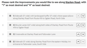
Ranking of transportation priorities

Ranking a list of potential improvement for Ogden road

The section of Ogden Road in this project area runs between the shopping center with Food Lion and Tanglewood Mall. It is a higher volume road with a 25 mile per hour speed limit that is likely rarely followed. It gets pretty wide, with five lanes at some points including turn lanes.

There are seven options provided to rank and here they are listed in the order that I ranked them:

  1. Sidewalk with landscaped buffer on west side of Ogden Road wherever space allows from Starkey Road north to the railroad bridge
  2. Crosswalks with pedestrian signals at the Starkey Road and Ogden Road traffic signals
  3. Bicycle lanes along both sides of Ogden Road
  4. Relocate Valley Metro stop southwest of railroad bridge with concrete pad for future improvements
  5. Sidewalk with landscaped buffer along west side of Ogden Road wherever space allows from Starkey Road south to existing sidewalk at Lewis Gale ER
  6. Travel lane reconfiguration on Ogden Road
  7. Slip land modification at Old Country Plaza

The proposed sidewalk on the west side of Ogden Road between Starkey Road and the railroad bridge would connect to an existing sidewalk built into the railroad bridge. While the existing sidewalk is relatively narrow, connecting to it is important to be able to connect to residential areas on the north side of the railroad bridge, including potentially to the City of Roanoke via Winding Way Road. To me, this proposed sidewalk section is also the major justification for the crosswalks, slip lane modification, and bus stop improvements proposed, so it is more important than those individual improvements.

The proposed crosswalks with pedestrian signals are very important for providing safer access to Tanglewood for people walking or biking on a sidewalk. It is honestly a bit hard to see how Roanoke County would implement this project and not provide these crosswalks, but they don’t exist currently and they wouldn’t connect to any sidewalks unless sidewalks are implemented as part of this project.

Like the proposed bicycle lanes on Starkey Road, the bicycle lanes proposed for Ogden Road would be consistent with the existence of bicycle lanes on surrounding roads, but as basic painted bike lanes are unlikely to significantly impact the number of people who would feel safe biking in this area. I rank them highly to voice support for bicycle improvements, but realistically these bike lanes are as likely to be used as those that currently exist along Electric Road where most people would likely choose to bike on the sidewalk.

Relocating the bus stop is a great idea because the existing bus stop is a sign stuck into grass with nothing connecting to it. Relocating the bus stop along a sidewalk would be a huge improvement and the proposed pad is looking forward to future improvements, like a shelter, that make waiting for a bus much better. Relocating the bus stop does not address creating a continuous sidewalk for people accessing it from residences north of the railroad bridge, but that is unfortunately outside of the scope of this project.

There’s a good argument that I’m under-ranking the proposed sidewalk from Starkey Road to the Lewis Gale ER. It is an important link to an existing sidewalk in the area and ties into the sidewalk along Electric Road. I rank it lower because it is a relatively short segment and it would be surprising if the county did not pursue it whereas the bicycle lanes and bus stop relocation feel easier for the county to not pursue absent positive feedback.

I rank the travel lane and slip lane modifications at the bottom because they are less about biking and walking improvements. If there was more information on the slip lane modification then I might rank it higher.

Open-ended comment box

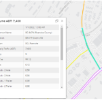
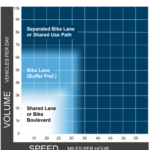
In the open-ended comment box I clarified my support of bicycle lanes in this study area by saying that they are unlikely to significantly improve bicycling in a way that encourages more people to bike in this area. According to the Virginia Department of Transportation, about 7,400 vehicles use Ogden Road each day which according to Federal Highway Administration guidance suggests a separated bike lane or shared use path would be the recommended bicycle facility for Ogden Road. While my ranking shows support for bicycle lanes, my true preference for bicycle facilities in this study area would be converting the proposed sidewalks to shared use paths with minimum widths of at least 12 feet. 

I think it was a major oversight that Roanoke County chose painted bike lanes for Electric Road instead of a shared use path along its north side. The painted bike lanes on Electric Road are intimidating to ride on and do not meet modern guidance. Continuing to use painted bike lanes in order to be consistent with those past choices only continues the error.

We are unfortunately kind of stuck with bad bicycle facilities to get to and around Tanglewood Mall. Modern guidance would recommend separated bike lanes or shared use paths along Franklin in the city of Roanoke and to Tanglewood as it becomes Electric Road, but the county likely relies on outdated AASHTO standards that are over a decade old. Unfortunately, painted bike lanes are the current facility within the city and along Tanglewood Mall. Painted bike lanes are also incorporated in future designs for a diverging diamond interchange between 220 and Electric Road. This is a failure of vision to create true bicycle connections that serve people of all ages and abilities and the sooner we can start addressing it the better.
Letter to the Editor: Williamson Road Safety Opponents Struggle with Facts

I wrote a letter to the editor that was published by the Roanoke Times on February 23, 2023. You can find the published letter here: https://roanoke.com/opinion/letters/letter-williamson-road-safety-opponents-struggle-with-facts/article_2a5421e6-b232-11ed-8d41-7fec6305fd48.html

This letter began by reviewing the letter to the editor referenced in my letter. I annotated their points and arguments and then wrote my letter based on the citations to facts that seemed most compelling at correcting points made by the safety project opponents. There’s a lot more potential context to provide, but I think this letter stands on its own and I’ll wait for the opponents to either continue to use bad facts or double-down on the few facts not explicitly addressed in this letter before responding further.

Here is the letter as I submitted it:

In their recent letter, “City should start over on Williamson Road plans,” Mr. Tanger and Mr. McClintock make many claims, but struggle to accurately provide or describe facts. 

The proposed plans for Williamson Road will improve safety. They fundamentally reduce the possibility for conflicts using a proven design that provides safety benefits. With yet another person walking killed on Williamson on February 17th, the facts continue to show a need for the safety improvements proposed.

Williamson Road safety improvements were developed by the Virginia Department of Transportation (VDOT) Project Pipeline process. Both a District Lead and Lead Consultant are named on the project page, in contrast to the insinuations about unnamed engineers and analysts in the letter. Facts can be found at: https://vaprojectpipeline.org/studies/salem/sa01-route-11—williamson-road.asp.

According to the Project Pipeline final report, there were 389 crashes on Williamson Road between 2015 and 2019. Of those 389 crashes, 75 were at the Orange Avenue intersection, less than 20%, not the 72% claimed by Messrs. Tanger and McClintock. The data is on page 24 of the report. Proposed changes at Orange Avenue are included on page 9, not excluded as they claim.

Road diets are a widely used and successful safety strategy. Far from being rejected or reversed in any significant number, at least 30 localities in Virginia pursued them in the last decade. A 2019 study by VDOT, available at https://www.virginiadot.org/vtrc/main/online_reports/pdf/20-r19.pdf, found that “39 miles of Virginia road diets across 66 projects…did not generally create traffic congestion problems” and over 70% met their primary goals. Of 25 projects with public feedback, none received majority negative feedback. 

The Safe Streets and Roads for All grant recently awarded to Roanoke will include community outreach, likely focusing in the area of Williamson Road, whose poor safety record was highlighted by the USDOT on its website discussing “our nation’s roadway safety crisis.”

The community deserves a factual discussion, not the misinformation provided by Messrs. Tanger and McClintock. The facts say Williamson Road is unsafe and the proposed changes will make it safer.

Letter to the editor: Williamson Road safety improvements a worthy pursuit

Yes, we need bike lanes. We also need to improve safety for everyone on our roadways. We should not let our feelings towards how people get around get in the way of creating a safer Roanoke for all of its residents and visitors.

I wrote a letter to the editor that was published by the Roanoke Times on October 11, 2022. You can find the published letter here: https://roanoke.com/opinion/letters/letter-williamson-road-safety-improvements-a-worthy-pursuit/article_c4f768d6-4430-11ed-b7f4-1f086b8d23ee.html

Here is the letter as I submitted it:

I am writing in response to Suzanne Osborne’s letter to the editor dated September 20, 2022.

Ms. Osborne first states that she was recently in France where she noted that “there are few bike lanes/paths – only narrow roads and crowded city streets with congested traffic, particularly in Paris….”

The mayor of Paris would almost certainly not agree that there are few bike lanes in the City of Lights. As of 2020, Paris had 650 miles of protected bike lanes, with another 125 in planning/construction. While bike lanes may not be present on all slower side streets, Paris has also made those streets safer by dropping most speed limits to about 20 mph. The mayor has committed to a “100% bikeable” city by 2026. These improvements in Paris have made the public streets much safer for all transportation users. 

Williamson Road is the most dangerous road in Roanoke, with 500 crashes and five people killed on Williamson Road in the past five years. To ignore this dangerous situation is irresponsible, and I applaud the City Council and VDOT for tackling this difficult problem head-on. 

Roanoke, which is approximately the same geographic size as Paris, has about 50 miles of bike lanes today, very close to where Paris was in 2000. With safety improvements like the one proposed for Williamson Road and the commitment of the City Council, we can begin to catch up. 

It is great that Ms. Osborne is such a safe driver. One of the great things about the proposed safety improvement for Williamson Road is that people crossing the street will only have to cross one traffic lane at a time. So a safe driver like Ms. Osborne can ensure the safety of the person walking and there is no second threat from another driver in a second lane. 

Yes, we need bike lanes. We also need to improve safety for everyone on our roadways. We should not let our feelings towards how people get around get in the way of creating a safer Roanoke for all of its residents and visitors.

Letter to the Editor: Fact Checking Fears about changes to Williamson Road

Even if congestion occurs, the lives saved by a safer design are worth a few seconds of delay. Mr. Bailey and Mr. Tanger will survive congestion, the people killed on Williamson Road will never get more time.

I wrote a letter to the editor that was published by the Roanoke Times on August 12, 2022. You can find the published letter here: https://roanoke.com/opinion/letters/letter-fact-checking-fears-about-changes-to-williamson-road/article_8ce37e64-1823-11ed-b8c5-d7da926ea0d2.html

Here is the letter as I submitted it:

The reason for proposed changes to Williamson Road is simple – the more than 500 crashes and five people killed on Williamson Road in the past five years – and the fears expressed by opponents do not align with facts.

Two recent opponents provide examples in need of fact checking. Ronald Bailey’s letter “Most not in favor of narrowing Williamson Road” doesn’t mention crashes or deaths beyond their effect on congestion. In speaking to the City Council, Bill Tanger said that 500+ crashes and 5 fatalities in five years was “not inordinate” suggesting that he is fine if people continue to die due to Williamson Road’s dangerous design.

Mr. Bailey and Mr. Tanger stoked fears about potential congestion instead of engaging with safety issues. Mr. Bailey expressed concerns about wrecks and stalled vehicles. Currently, Williamson Road averages a crash every third day. The proposed changes would reduce conflict points and provide a dedicated turning lane to reduce crashes and congestion. Stalled vehicles could use the bike lane, center turn lane, or adjacent parking lots to clear the travel lane. 

Mr. Tanger claimed that the proposed changes to Williamson Road do not work well on roads with 25,000 or more vehicles per day, but Virginia Department of Transportation data shows that Williamson Road has less than 15,000 vehicles per day. According to the Federal Highway Administration that makes a road like Williamson a “good candidate” for the proposed changes. Even if congestion occurs, the lives saved by a safer design are worth a few seconds of delay. Mr. Bailey and Mr. Tanger will survive congestion, the people killed on Williamson Road will never get more time.

The proposed changes to Williamson Road are first and foremost for the safety of people who live, walk, and drive on Williamson Road. Delays due to proposed changes on Williamson Road are speculative. The crash and fatality data on Williamson Road are real. I want a safer Williamson Road and would be far more likely to visit businesses there if I felt safe on Williamson Road.

The Bane of Bradshaw

The Bane of Bradshaw

Narrow Fast Dicey Edge Road

Route 311

When you come to Roanoke and want a great road cycling ride, the Bradshaw Road route is one of the first to come to mind. Visit Virginia’s Blue Ridge says, “The Bradshaw Road route is one of the most popular rides for local biking enthusiasts in Virginia’s Blue Ridge.” 

It is 47 miles of rolling hills, gentle climbs, and fast descents. If you’re riding with a group there’s a nice climb to a red mailbox that is also perfect for a sprint. I’d recommend it to anyone coming to Roanoke who wants a great road ride. Except, they have to be okay with a dangerous and scary stretch on Route 311.

On Route 311 there is a roughly 2 mile stretch that is fast and narrow in the worst ways. It is a 55 MPH road. It has areas that might be shoulders that are less than 4 feet wide. There are drop offs and pinch points that place people biking directly in the way of semi trucks, large pickups, and other traffic with that traffic expecting to move at 55 MPH. A 2001 Roanoke Times article, updated in 2019, about the Bradshaw route described this section of 311 as “a dicey road” and said “that anybody, no matter how experienced on a bike, is a fool to try to ride on U.S. 311 at any time other than early on a weekend morning.”

If you are comfortable taking the lane and slowing down traffic or riding in a group that can slow traffic, and ride at an appropriate time, then the Bradshaw route is a great ride and I heartily recommend it. If you are not comfortable mixing with 55 MPH traffic then I can’t recommend it.

311 is a fast road. Cyclists can go 20 mph consistently and groups may go even faster.  But even at 30 mph there is still a 25 mph speed differential, creating tension with people who want to go faster.

The 2 mile stretch of 311 between the Hanging Rock Battlefield and Bradshaw Road is the bane of the Bradshaw cycling route. It is the place where a cyclist feels closest to death. You may not be hit, or passed closely, or lose control off the side of the road, but you are almost guaranteed to be exposed to 55 MPH traffic for some period of time. It is remarkably fortunate that no cyclist has been killed on this section of 311 (at least in VDOT data since 2014), although one person was killed in a vehicle at the turn for Bradshaw Road. For some people, the experience of this section means they will not be able to experience the Bradshaw route, or they might be scared off from cycling by the experience.

Fixing the bane of Bradshaw would be a great boon for the cycling community in Roanoke. It is an awful experience in the midst of a great one. More people new to biking might give Bradshaw a try and like it. More people might feel comfortable biking Bradshaw more often. It is a very approachable longer ride, and fixing this stretch is the key to making it even more approachable.

So, what are some solutions? How can we make the Bradshaw route an approachable ride for more people? 

Here are a few ideas:

Lower the speed limit

  • I feel like 40 mph is appropriate for this road. Likely to have minimal travel time impacts. Tourist traffic to McAffee’s Knob isn’t too time sensitive. Swap out signs. Add feedback signs. Maybe do enforcement. People will probably adjust. I bet the speed limit wasn’t initially based on a traffic study.

Add shoulders and rumble strips

  • This is the most obvious solution. The difficulty is the solution’s expense. It may require acquiring right of way, but there’s also a lot of potential for driveway and drainage improvements for adjacent homeowners. Rumble strips would need an appropriate skip pattern so that bicyclists are not trapped by them. Rumble stripes, where the rumble pattern is made on the striped edge line, might be good due to limited space. Not sure of the actual expense.

Provide a waiting area for left turns

  • At the turn to Bradshaw Road it would be nice to have a small waiting area on the right side of 311. This would allow cyclists to pull over and wait for traffic to clear before turning onto Bradshaw instead of holding up traffic waiting for a gap. This might improve safety as it would allow cyclists to move out of traffic and have more time to find a gap they are comfortable with.

Trail?

  • The 2018 Greenway Plan has a project called the Mason’s Cove Greenway. It’s described on page 56: “4.2.30. Masons Cove Greenway, Map #30, Category 4 The Masons Cove Greenway would connect Mason Creek Greenway to Catawba Greenway utilizing an old railroad bed. Bicyclists could use this route to get up the mountain and connect to Rt. 311 to reach U. S. Bicycle Route 76.” The plan makes it appear to be a theoretical possibility, but there is little information on status other than that the railroad bed exists. Could be worth exploring, but this is likely more expensive than improved shoulders.

Road reconnection?

  • No, there’s a short unconnected road that connects to the Hanging Rock Battlefield, but it’s too short to do much to improve this stretch of road. It could be a cool connection for Just the Right Gear to provide access to the Hinkey Trail, but that would still require a significant reworking of the shoulders and striping along a shorter section of 311.

Restriping?

  • No, pretty confident that the road is actually narrow in places and does not have sufficient width to provide at least 5 foot shoulders through restriping.

Rumble strips only?

  • No, rumble strips only would make what little shoulder exists unrideable. Cyclists would be forced into the travel lane and this stretch of 311 would be even more of a barrier for people not comfortable slowing down traffic or being passed by 55 MPH traffic.


Comments to City Council on Plan 2040

I submitted this statement to the City Council in December 2020 after the adoption of the 2040 Comprehensive Plan. I was unable to attend the City Council meeting, which was much easier to attend when it was conducted with a Zoom and/or Facebook Live call-in option.

——- 

I want to thank the members of the City Council and the City of Roanoke for creating a comprehensive plan that prioritizes equity, health, and safety in so many areas.

Over the last 20 years Roanoke has created a great greenway system and many miles of bike lanes, and I am glad the 2040 plan continues investments in biking and walking to create complete neighborhoods. The City’s plan says that “complete neighborhood[s] [are ones] built at a human scale, [are] pedestrian friendly and bikeable, and meet the needs of people of all ages and abilities.” 

In the Livable Built Environment priorities, Policy 3 “Create accessible neighborhoods” there is an action item to create a “transportation mobility priority plan prioritizing pedestrian and bicycle accommodations.” I think a City plan for high quality pedestrian and bicycle facilities is very important so that the City can deliver the accessible and complete neighborhoods envisioned by the City’s Plan.

The importance of planning for pedestrian and bicycle facilities can be seen in Roanoke’s Greenway system, which has had three plans adopted about every ten years since 1996. Planning for the greenway system as a whole and for its constituent parts has helped make the greenway a touchstone of the City of Roanoke.

The pedestrian and bicycle plan called for in the City’s 2040 plan, should be a plan for the City of Roanoke, draw from neighborhood plans over the last 20 years, and look forward to meet the needs of Roanoke’s future. The last regional bicycle plan was adopted in 2012 and I hope a bicycle and pedestrian plan for the City is a priority in the next few years.

Large projects, like the Downtown Roanoke Urban Loop contained in the current downtown neighborhood plan, need planning to become reality. A City pedestrian and bicycle plan will also help the City compete for state and federal funds needed for such projects. 

I want to thank everyone who contributed to creating the City’s 2040 plan and look forward to the improvements promised for biking and walking, and for equity, health, and safety.

PlanRoanoke icon

Statement to City Council on Labor Day Weekend Pedestrian Deaths

The Roanoke City Council resumed in person City Council meetings and did not offer a call-in option on September 8th. I was unable to attend in person, but drafted this statement which was printed and distributed to City Council in lieu of my ability to read it.


Thank you Mayor and members of the City Council for hearing me today. In May, I spoke to the Council about a person walking who was hit and killed on Brandon Avenue. 

Today, I am speaking because three people were killed by drivers while walking in Roanoke in the last week.

  • On Thursday, September 3rd, Albert Cager Jr. was hit and killed by a driver on Salem Turnpike NW.
  • On Friday, September 4th, a man and woman were hit by a driver on Williamson Road NE. The woman died.
  • On Monday, September 7th, a woman was hit and killed by a driver on Hershberger Road NW.

When the City of Roanoke launched its “Every Corner is a Crosswalk”pedestrian safety campaign this summer, three people had already been killed while walking in the city this year. Now, that number has doubled in less than a week.

The City of Roanoke needs to do more than admonish drivers to respect the legal rights of people walking. The City of Roanoke needs to take positive action to make its streets safer – it needs to invest in safe sidewalks throughout the city, invest in street lighting, and invest in crosswalks and infrastructure to slow down drivers and give space to people walking.

This deadly week highlights the need for the City Council to provide leadership to Roanoke’s built environment and correct past mistakes that have created dangerous conditions for people walking and biking. The Department of Public Works, City Manager, and others involved in making our streets safe, or unsafe, need to know that the City Council believes traffic deaths are preventable and supports them prioritizing the safety of people over the speed of vehicles.

Whether planning for a livable built environment in the City’s next Comprehensive Plan or making decisions about corridors during repaving, the City of Roanoke needs to actively decide to prioritize the safety of people walking, biking, taking transit, and driving in order to prevent tragedies like this in the future.