The City of Roanoke was awarded a $480,000 Safe Streets and Roads for All grant from the United States Department of Transportation. With a 20% match, the city will have $600,000 to create an Action Plan to dramatically reduce traffic deaths in the city. The counties of Roanoke and Botetourt also received a grant.
The Safe Streets for All Grant is an incredible opportunity for the city to create a plan that will address the dangers faced by people biking, walking, driving, and taking transit. Included in the grant are dedicated dollars for collaboration with Virginia Tech, community engagement, and data-driven examinations of why people are killed and seriously injured on Roanoke’s streets.
Released with the USDOT’s announcement was a cool data tool, and this blog post digs into what that data tool says about Roanoke.
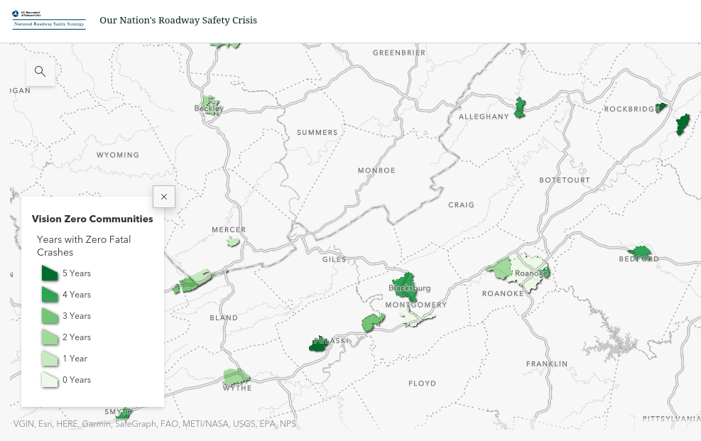
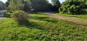
One way that USDOT presents data is by showing communities that have experienced zero fatal crashes. In the Roanoke region, several communities report zero traffic fatalities in recent years including Blacksburg and Vinton (4 years) and Salem (2 years). The city of Roanoke has zero years with zero traffic deaths according to USDOT.
Map of communities with years with zero traffic deaths
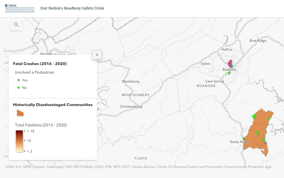
Another way that USDOT presents data is by showing traffic deaths in historically disadvantaged communities. In the Roanoke region, there are two historically disadvantaged communities in the city of Roanoke and Franklin county is also a historically disadvantaged community.
Map of Historically Disadvantaged Communities
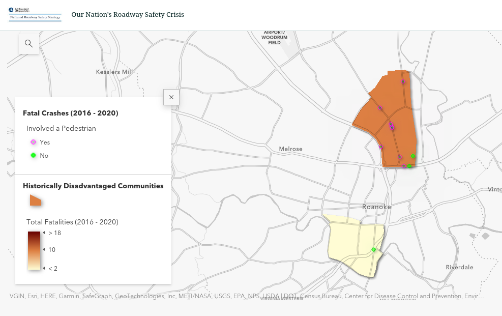
Zooming into historically disadvantaged communities in the city of Roanoke, we see that there is a tract that covers parts of the Old Southwest neighborhood and a tract that covers parts of NE Roanoke centered around Williamson Road. The tract in NE Roanoke has far more traffic fatalities than Old Southwest, and many more are people walking.
Traffic Fatalities in Historically Disadvantaged Neighborhoods in Roanoke
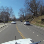
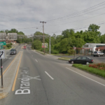
In NE Roanoke there are two obvious concentrations of fatalities:
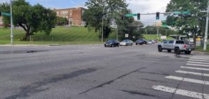
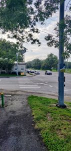
Williamson Road
At least 5 people were killed on Williamson between 2016 and 2020
Williamson Road has a planning history and has been a source of competing letters to the editor and neighborhood groups
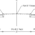
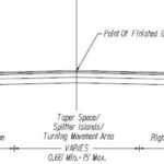
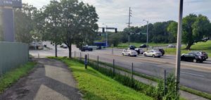
Focus has been on operations (traffic flow), not safety. Pedestrian environment is challenging. Biking is discouraged. Significant potential foot traffic from Berglund Center, but no safe and easy crossings. Traffic is high speed and high volume. Crossing distances are long. Slip lanes are at intersections and merges from the highway.
The City of Roanoke’s Safe Street and Roads for All grant includes many activities, including:
Engagement
Speed Management
Demonstration Projects
Video Analytics and modeling
I think the USDOT tool does a good job of providing information useful to guide the implementation of Roanoke’s grant. It identified areas where the city already has ongoing plans. The grant can guide these plans into projects that create safer streets and listen to community traffic safety concerns to design for community needs.
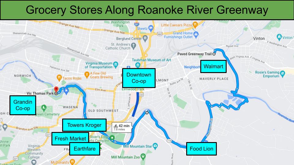
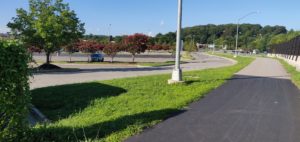
The Roanoke River Greenway runs about 8 miles from Vic Thomas Park to Fallon Park. Along the way it passes six full-service grocery stores with fresh fruit and vegetables. The trip to the grocery store is a great trip for biking. From the greenway, each store is less than a mile away with the furthest away store being the Grandin Co+op.
This post looks at how people get from the Roanoke River Greenway to those Groceries. There are many people who only ride on greenways recreationally. A trip to the grocery store is a great way to get those people to try riding for utility. Whether buying a treat or a meal’s worth, a trip to the grocery store helps a rider understand how to carry things well, how to park, and off-greenway routing.
Map of Roanoke River Greenway with nearby grocery stores
Here are the six grocery stores along the Roanoke River Greenway from left to right:
Grandin Co-op: .6 miles away
Towers Kroger: .4 miles away
Fresh Market: .4 miles away
Earthfare: .4 miles away
Food Lion: .3 miles away
Walmart Neighborhood Market @ Fallon Park: .4 miles away
Ease of Biking
Transition between Roanoke River Greenway and Memorial Drive in Grandin
Overly large roundabout with slip lane and small median island near Food Lion
Wide part of Franklin Ave with “suicide” bike lane
Complicated intersection at Brandon Ave and Main Street in Wasena
Hill up Brandon Ave towards Towers Shopping Center
Crosswalk between Fallon Park and Walmart
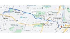
Below are the six grocery stores along the Roanoke River Greenway based on how easy and safe they are to ride to, in my opinion (I live in Wasena, so my experience of these trips is from Vic Thomas Park). The image gallery above shows what I consider the worst parts of each ride:
Grandin Co-op: It has bike lanes most of the way, but there are issues. The intersection on the east side of the Memorial bridge is awkward and high speed. It is hard to transition from the greenway to the west-bound bike lane that leads to the Grandin Co-op. The bike lane disappears approaching Grandin Road and a rider must merge into a left turn lane and turn left in a shared lane to reach the grocery store.
Food Lion: It’s the shortest and if you use sidewalks it’s pretty easy, but the new-ish roundabout with pedestrian crossings was poorly designed for this connection and is out of the way. Taking the shorter route puts you on the widest part of a narrow road that sometimes has speeding issues. The roundabout has a slip lane that widens the road to two lanes for a short section near where a person riding would turn left to go to the grocery store.
Earthfare: If it wasn’t for that stupid suicide lane this would be number one. By suicide lane I mean the bike lane striped between a through lane and a long right turn lane on Franklin Road. That intersection and its approaches are a mess. Would be much improved by establishing a connection from the greenway west of Franklin through the old Ramada parking lot. But this is a pretty straight shot with a bike lane and often limited traffic.
Towers Kroger: There are bike lanes on Main Street, Franklin Ave, and Brandon Ave, meaning bike lanes are only missing at intersections. Towers can be approached from Wasena Park or River’s Edge Park. For the purposes of ranking, this entry is for the approach from Wasena Park. The intersection at Brandon Ave is a doozy, but surprisingly easy to navigate once you’ve done it a time or two. Heading east is a high speed protected left turn while heading west is an awkward climb in a right turn lane that seemingly always has a green light. The presence of a bike lane to the left of the right turn lane may lead some people to believe that you should be in the bike lane until the right turn, but that sets up a potential conflict point with cars already in the right turn lane. Overhanging trees obscure the light for the right turn lane and the short two lane section approaching Main Street invites cars to try to overtake you and then cut you off, but most cars will stay behind you if you take the right turn lane.
Fresh Market: The approach to Towers from Franklin Ave is worse, in my opinion, than the approach from Wasena/Main Street. Approaching from River’s Edge/Franklin Ave there’s a big left turn across four lanes of traffic that leads into a wide road and a long right turn lane. It’s a short section, but it feels really dangerous and exposes you to multiple vehicle threats. The climb to Towers, or return to the greenway from Towers, is on a section of Brandon Ave where the road diet was not continued after the intersection with Colonial, meaning that bike lanes are unmarked and narrow, and there are at minimum four lanes of traffic to navigate. To return to the greenway, there’s a dual left turn lane which creates uncertainty and the potential for conflict.
Walmart Neighborhood Market @ Fallon Park: It’s a sidewalk special, but not a bad one. There are no bike facilities, but if you navigate using the sidewalks then it is a pretty straightforward ride. My preference is to ride the sidewalk along the northside of Dale Ave to Vernon St and cross at the light, then it’s just a short section to the parking lot entrance. Going to this grocery store from the greenway doesn’t make a lot of sense for many people due to where the greenway connects to neighborhoods, the Tinker Creek Trail extension may make this more accessible.
Bike Parking
Bike Parking at Grandin Co+op
Bike Parking at Fallon Walmart
Bike Parking at Earthfare
Bike Parking on Kroger side of Towers
Bike Parking at Fresh Market side of Towers
Cart Return at SE Food Lion
Below are the six grocery stores along the Roanoke River Greenway based on the quality and location of their bike parking. The gallery above shows an example of bike parking at each location:
Grandin Co-op: Classic staple racks right out front on a large sidewalk with a curb. Some cover provided by trees.
Walmart Neighborhood Market @ Fallon Park: Large and well spaced staple racks in front of the store. A little bit far from the entrance, but very good overall.
Earthfare: A wave rack right out front on a large curbless sidewalk at parking lot level
Towers Kroger: There are two small staple racks located too close to pillars on the Kroger side of Towers. Multiple cart returns and some hand railings provide alternative spots.
Fresh Market: There is one small staple rack located so that you must walk through the mall to reach Fresh Market from it. Fewer cart returns and alternative spots.
Food Lion: No bike parking, so cart return is the best place to park your bike.
Bonus stores
Downtown Co-op
Just outside of one mile from downtown
Some of the best bike parking
Streets are slow, but there’s no bike infrastructure downtown, greenways kind of disappear, one-way grid is not welcoming from the west
LEAP (Tuesday pop-up market)
Short and simple ride from greenway to West End Center
Bike lanes the whole way (kinda), alleyway is nice
Grab and go makes parking easy (just lean your bike on the wall)
Brambleton Krogers (Gucci @ 4404 and Other @ 3971)
Gucci is far away and doesn’t offer enough of a reason to go there for the distance
The closer Kroger isn’t too bad and can be paired with trips to Ace Hardware, no awful intersections since you don’t go past Electric Road
Valley View
Further away, but the Lick Run Greenway is nice
Useful for Best Buy and sometimes other stores
Viable for people who live along the Lick Run Greenway north of Orange Ave
Vinton Kroger
Hardy Road is awful
Approaching from 3rd Street/Wyndham Drive is kind of scenic but out of the way and not great
The bike rack is like a mix between a wave and a staple rack and too close to a column to be used correctly by more than two bikes
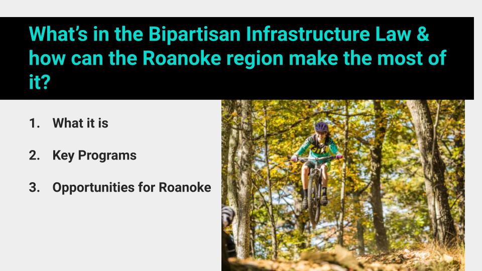
What’s in the Bipartisan Infrastructure Law & how can the Roanoke region make the most of it?
As Chair of the Roanoke Valley-Alleghany Regional Commission (RVARC)’s Bicycle and Pedestrian Committee I gave a presentation for the committee on the Infrastructure Investment and Jobs Act, also known as the Bipartisan Infrastructure Law (BIL). My goal in that presentation, and in this blog post, is to explain:
What the Bipartisan Infrastructure Law (BIL) is
Describe Key Programs and Concepts for taking advantage of the BIL
Identify Opportunities for Roanoke to maximize the BIL for biking and walking
The BIL is a Trillion dollar investment in infrastructure. It is larger than, but includes a five year authorization of federal transportation funding. For the state of Virginia, the BIL means we can expect $7.7 Billion in federal transportation funding by 2026, a 33.5% increase from current funding levels. In addition, there are more than 200 Billion in competitive grants that can further increase funding available for localities in Virginia.
Key Programs and Concepts for taking advantage of the BIL
Most of the $7.7 Billion that Virginia receives under the BIL will come through formula fund programs. While biking and walking projects are eligible under most formula fund programs, the programs most likely to fund biking and walking projects are:
The Transportation Alternatives Program (TAP)
The Congestion Mitigation and Air Quality Improvement Program (CMAQ)
The Surface Transportation Program (STP)
The Highway Safety Improvement Program (HSIP)
TAP is the long-time source for a majority of biking and walking projects in most states, and the smallest of these four programs. STP is the largest and most flexible program. CMAQ and HSIP tend to be more quantitatively driven, and have been used effectively for biking and walking projects in some places.
In Roanoke, planning documents say that Roanoke plans to get $700-800,000 each year from TAP. Thanks to the BIL, Roanoke can expect TAP funding to increase 50%, up to $1.5 Million per year. According to past data, Roanoke tends to award two to three TAP projects each year, with a one year lapse in 2019 when no projects were awarded. TAP funding has been critical to the growth of the greenway system.
The future of transportation projects in Roanoke can be found in the RVARC Transportation Improvement Program (TIP). A TIP is a federally-required planning document that projects must be included in if they are to receive federal funds. By looking at the existing TIP, we can see where Roanoke expects funds from the BIL to go and identify potential opportunities.
In reviewing the Roanoke TIP, it is notable how much federal funding is going to I-81 and related projects. The state of Virginia has dedicated a regional gas tax to I-81 and that revenue stream is leveraged by nearly $700 million in federal funds in the Roanoke TIP. Three projects related to I-81 are 74% of planned spending in the largest category of spending, “Safety/ITS/Operational Improvements.”
In the Roanoke TIP, biking and walking projects and elements are found throughout funding categories, but are concentrated in the category “Transportation Enhancement/Byway/Non-Traditional.” Transportation Enhancements was the name of a predecessor program to TAP, but has not been used in federal law since 2012. Within the Transportation Enhancements category, greenway projects are the majority of planned spending. Overall, $53 million in planned projects are found in the Transportation Enhancements category.
Four greenway projects are planned that cost a combined $27 million. At a rate of $1.5 million/year it would take TAP funding 18 years to fund those four projects, if no other biking and walking projects were funded during that time. If we want to make those projects a reality faster, then we must find opportunities in other funding programs or through discretionary grants. Because I believe that proposals are motivating and likely to be beneficial for finding funding from any program, focusing on discretionary grants is where I see the biggest opportunities for Roanoke.
Opportunities for Roanoke to maximize the BIL for biking and walking
The big opportunity for Roanoke is a RAISE Grant. RAISE Grants are the largest discretionary grant program in the BIL and the program with the longest track record. Through 2026 there will be $1.5 Billion/year distributed through the RAISE program.
The Biden administration has administered one year of the RAISE program. The RAISE program replaces the BUILD program which replaced the TIGER program. Since Congress authorized the TIGER program, each administration makes its mark on the types of projects funded.
For certain qualifying communities, RAISE can fund the entire project, and the Biden administration has committed to 15% of grants going to qualifying communities. The Biden administration has also added quality of life criteria that make projects that reduce automobile dependence more competitive. Even prior to those positive changes, RAISE had a good track record of funding biking and walking projects.
The Biden administration has funded several types of bicycle and pedestrian projects under the RAISE program that Roanoke can learn from.
Completing greenway networks
There were four greenway projects funded where the funding finished a network or segment.
Example: Completing the Vision – The Marquette Greenway builds 20 miles of the Marquette Greenway to complete a 60 mile path with an award of $18 million and a total project cost of $31 million.
Greenway network progress
There were four greenway projects funded where the funding provided for a critical connection, but most of the proposed greenway or network is unbuilt.
Example: Durham Belt Line builds 1.75 miles of trail with an award of $9 million and a total project cost of $16 million.
Community hubs
There were four projects that funded improvements on a grid of streets to create bicycle and pedestrian spaces around a community hub.
Example: Rockford Complete Streets Revitalization Project builds streetscape on multiple streets in a grid with an award of $16 million and a total project cost of $22 million.
RAISE grants have an average project size of $10-20 Million, $25 Million max. Looking at planned Roanoke bicycle and pedestrian projects, there are a few candidates for a RAISE grant:
Tinker Creek Greenway to Carvins Cove
The Tinker Creek Greenway is planned to be 13.3 miles total. There are 3.3 miles built, one 2 mile section funded by a TAP grant, and there are 10 miles needed.
A RAISE grant for the 10 miles needed would pay for planning, engineering, and building. From what I have heard, right of way may be an issue and is not yet owned by any public entity. RAISE grants do not fund right of way acquisition.
Roanoke River Greenway Completion
The Roanoke River Greenway is planned to be 30 miles total. There are 13.8 miles built, multiple sections funded by TAP grants, and there are 17 miles needed with $22 million in projects on the TIP.
A RAISE grant for the remaining miles would pay for the sections on the TIP if that funding is uncertain. In the case of the greenway section to Explore Park, a RAISE grant could play a role in resolving design issues with VDOT. The area on the south side of Apperson is the most troublesome section I’ve heard of.
There are several less planned projects that might be viable within the next five years. These projects would require significant planning.
NW Hub
For many years there has been interest in developing a grocery store and other community needs in a hub space in northwest Roanoke. In 2021, the Roanoke City Council voted to direct $10 million in federal funds from the American Rescue Plan Act (ARPA) to bring a shopping center to the neighborhood. At this point, there should be land acquisition occurring so that the hub can be developed. A grocery store is fairly large, so it will be interesting to see the ultimate site that is developed.
A RAISE grant would improve bicycle, pedestrian, and transit access between the northwest hub and other key community hubs, such as Downtown or Williamson/Valley View. Key components might be a shared use path on Shenandoah, crosswalks and a protected bike lane on Melrose, a protected bike lane on 24th Street, crosswalks and a protected bike lane on Salem Turnpike, and transit stop improvements. Hub site selection will impact most pertinent projects.
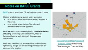
The NW Hub site is likely to be within a Historically Disadvantaged Community that is eligible for 100% federal funding. Every census tract in the near northwest except tract 24 is a Historically Disadvantaged Community.
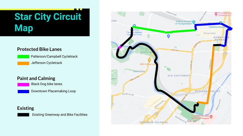
The 2017 Downtown Neighborhood Plan proposed a Downtown Roanoke Urban Loop that would create a six mile system of safe routes connecting key neighborhoods in downtown Roanoke. In 2021, I proposed a version of this route for an AARP grant and called it the Star City Circuit. By connecting downtown to River’s Edge, Wasena, Grandin, Hurt Park, and the West End, the Star City Circuit is an incredible opportunity to create connections near downtown and build on Roanoke’s impressive Roanoke River Greenway by better connecting it to downtown.
A RAISE grant would pay for a protected bike lane on Jefferson Road as part of a road diet, a protected bike lane on Reserve, downtown intersection improvements, two-way bicycle improvements along Norfolk Ave, and a protected bike lane on Campbell Ave and/or Patterson Ave. There is likely to be some disagreement about route and design choices. The road diet on Jefferson Road is planned and 2.3 miles of the six mile route is built thanks to the Roanoke River Greenway.
Notes on RAISE Grants slide
There are lots of other discretionary grants aside from RAISE. For now, a brief idea about other grants and potential projects can be found on the last slide of my presentation.
It’s been awhile since I’ve posted. Part of that lapse was working on a grant proposal for Roanoke Outside this spring. That grant proposal was one of over 3,000 for an AARP Community Challenge Grant and one of over 3,000 that were not funded.
My grant proposal was called the Star City Circuit. The Star City Circuit is a proposal for the largest pop-up bike network in Virginia history, connecting 6 miles of Roanoke with protected two-way bike lanes, existing bike infrastructure like the Roanoke River Greenway, and a downtown route of low-traffic streets. In concept, it is a demonstration of the Downtown Roanoke Urban Loop from the 2017 Downtown Neighborhood Plan and which I blogged about a year ago in July 2020.
Map of the 6 mile Star City Circuit proposal
My grant proposal for Roanoke Outside asked AARP for $10,000 to implement a one-day demonstration project. While the AARP email informing Roanoke Outside of not getting the grant did not provide feedback, my guesses for why the proposal did not receiving funding would be:
There was no local match for the $10,000 ask. Other grant programs, like the People For Bikes Community Grant, will not fund proposals asking for more than 50% of the funding required. For future success, local fundraising will likely be key.
Roanoke does not have a record of pop-up demonstration projects. While Roanoke does sometimes close streets for events, has a great chalk-up the city scene, and has an admirable record for safe street reconfigurations, there is little record of temporary street changes. Going from no record to the largest pop-up in Virginia history is a big jump.
The proposed design was not fully vetted by important stakeholders. Major sections of the proposed project pass directly by law enforcement agency offices and the largest employer in the region, Carilion Clinic, and I didn’t secure letters of support from either. Getting the support of both will likely be important for future success.
So, what is the Star City Circuit?
Well, as one project it is 6 miles of connected Greenway, two-way protected bike lanes, low-traffic streets, contraflow lanes, signs, and improved intersections. But, it’s probably best described as three improved corridors and one major intersection improvement.
First, the Star City Circuit is not possible without Roanoke’s existing bike infrastructure. It uses existing bike infrastructure for about 43% of its length, primarily the Roanoke River Greenway between Black Dog Salvage at Memorial Bridge and the River’s Edge Sports Complex.
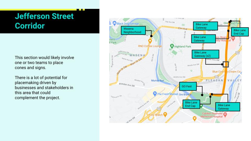
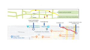
Jefferson Street Corridor
Jefferson St Corridor of Star City Circuit
The easiest to implement improved corridor is Jefferson Street between Elmwood Park and River’s Edge. In this section, Jefferson Street is a road that meets federal criteria for a road diet – meaning that an existing travel lane can be repurposed without much negative effect on congestion – and that congestion may even be improved by converting an existing travel lane into a center turn lane. For the purpose of the Star City Circuit, and the proposed Downtown Urban Loop, this means that Jefferson Street can have its west-most lane converted to a two-way protected bike lane. With enough traffic cones, the west-most lane can be dedicated to people biking, walking, and scooting. At Reserve Road, this lane would use the slip lane to make a fully separated turn towards River’s Edge Park before connecting with the Roanoke River Greenway. By connecting River’s Edge Park, South 16 Apartments, and the Virginia Tech-Carilion Clinic Fralin Biomedical Research Institute to downtown, this is a potentially transformative link on its own.
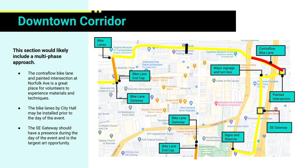
Downtown Corridor
Downtown Corridor of Star City Circuit
The next corridor is not, strictly speaking, a corridor. But it is the section of low-traffic streets from 3rd Street SW to 3rd Street SE that allows the Star City Circuit to navigate downtown without causing much disruption to downtown. The most direct route would use Campbell Avenue and Market Street to create a loop, but that would require repurposing probably 50-100 parking spaces downtown. Instead, to avoid displacing parking, the Star City Circuit proposal uses a somewhat meandering route that avoids car traffic. Going left-to-right, the proposal begins at Campbell Avenue and 3rd St SW, then goes on 3rd St SW towards the Virginia Museum of Transportation before turning onto Norfolk Ave SW and continuing on Norfolk Ave SW until it hits Campbell Ave SE, taking a quick right turn on Campbell Ave before a left onto 3rd St SE, then following 3rd St SE until it turns into Bullitt Ave SE and then the Elmwood Art Walk. This meandering route has the advantage of including the future downtown transit center, low-traffic on all segments except the quick half-block on Campbell Ave, and great potential for future development.
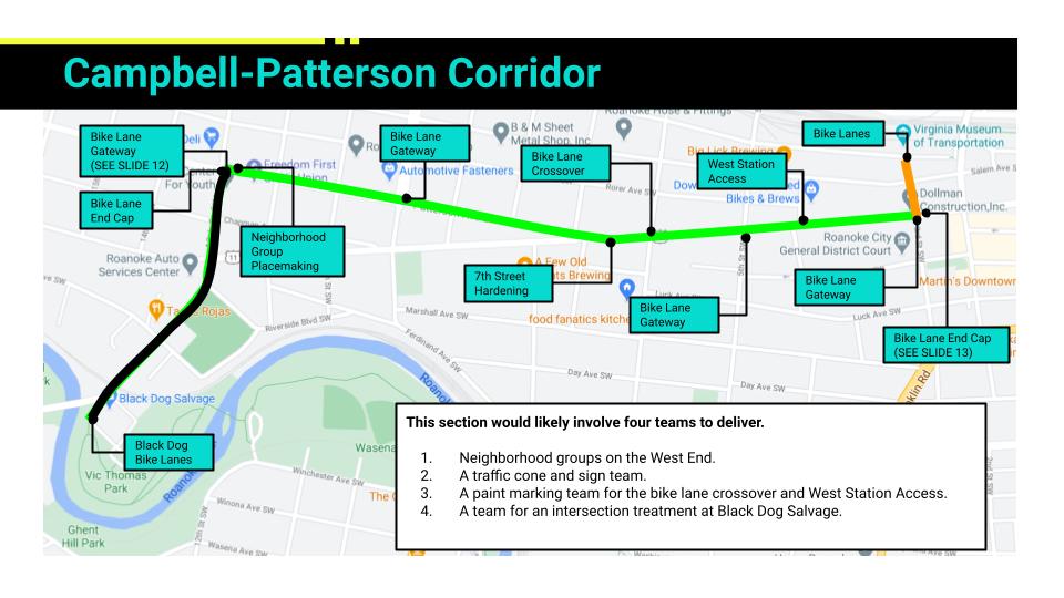
Campbell-Patterson Corridor
Campbell-Patterson Corridor of Star City Circuit
The final corridor is the most complicated and goes from 13th Street SW to 3rd Street SW. In those ten blocks there are several major challenges that require careful attention as a pop-up project and as a long-term project. The Star City Circuit proposal attempts to balance the issues, but this is a corridor where experience and feedback from the pop-up will be critical to the long-term solutions.
The biggest challenge in this corridor is the Y-intersection of Campbell Ave and Patterson Ave, where a man died in a motorcycle crash in 2020. This intersection has relatively higher traffic, a high-speed unprotected left turn, and an elevation change that creates visibility issues. The way that the Star City Circuit deals with this challenging intersection is by repurposing the northmost lane on Patterson Ave to avoid conflicts at the intersection and then switching sides of the road at 6th Street in order to better use space on the south side of Campbell Ave. The preference of the Mountain View Neighborhood Association, located on the West End of Campbell Ave, would be to use Campbell Ave the entire way. However, that is only possible by taking all of the parking spaces from 13th Street SW to 6th Street SW or making Campbell Ave a one-way street for that segment. Either of those solutions is complicated for a pop-up, but either could be possible in the long-term.
Another major challenge for the 13th Street SW to 3rd Street SW corridor, is the complex of the Roanoke City Jail, Roanoke City Sheriff Office, and Roanoke City Police Department between 4th Street SW and 3rd Street SW. In this section, there are about 8-10 parking spots reserved for law enforcement that likely need to be maintained for any demonstration project and for the long-term. The Star City Circuit deals with this by creating a parking protected bike lane that preserves these parking spots – the first parking protected bike lanes in Roanoke, and maybe the Roanoke-Alleghany Valley. While complicated to implement as a pop-up, this will allow the community to interact with, and react to, a new type of bike infrastructure that may be used in the future.
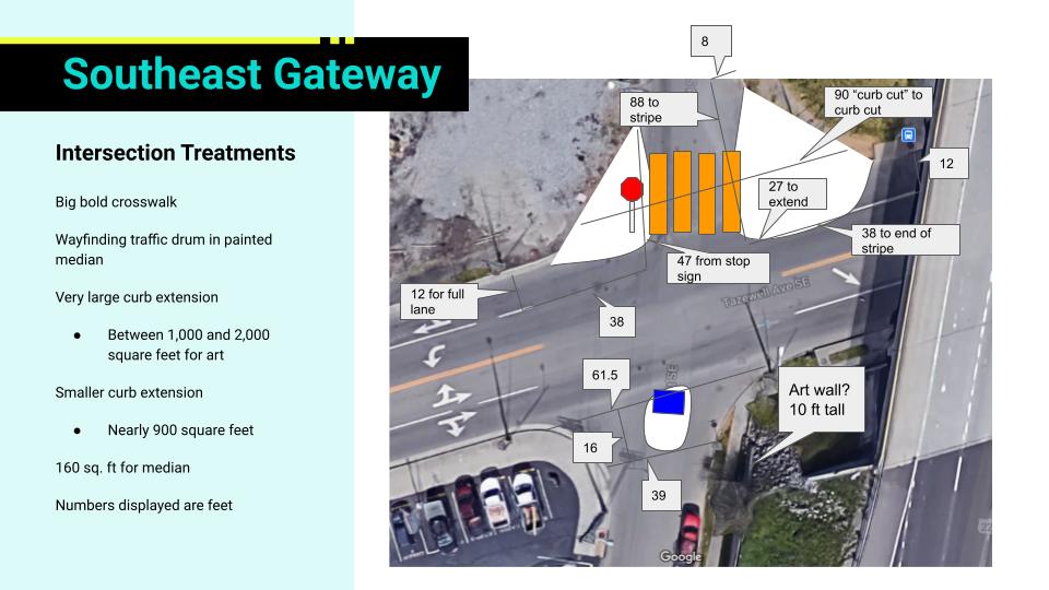
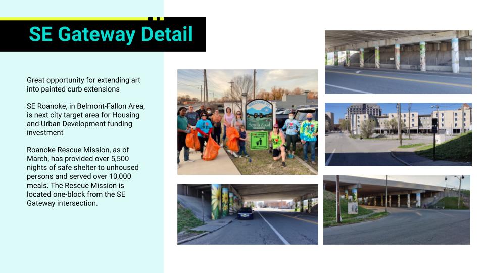
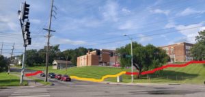
SE Roanoke Gateway Intersection
SE Gateway Measurements
SE Gateway Concept
The one major intersection improvement that deserves attention is at 3rd Street SE and Tazewell Ave SE. This intersection is currently between a wide four-lane road in Tazewell Ave SE and a smaller two lane road in 3rd Street SE. There are sweeping corners and no crosswalks despite a bus stop and good foot traffic as the closest access between SE Roanoke and downtown. In the Star City Circuit proposal, this intersection is calmed through large painted curb extensions, crosswalks, and small median islands. It is also an ideal intersection for a pop-up tent and potential future development.
And, that’s the essence of the proposal. As far as I can tell, if this proposal is implemented it would be the largest pop-up bike network in Virginia history and likely one of the 5 or 10 largest in US history. While there are some complicated parts, there’s nothing stopping this from being implemented.
Next steps for this project are still in flux. I’m looking to do local fundraising and I’m looking to do a smaller project to test pop-up materials such as temporary street paint. If you’re interested in this project, please reach out!
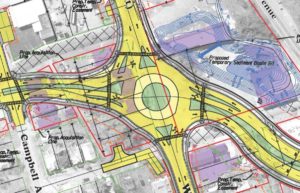
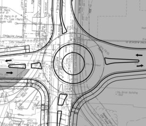
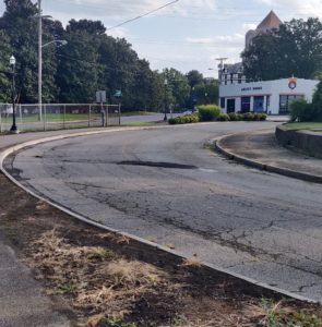
The biggest difference is the change from a multi-lane roundabout to a single-lane roundabout. This should make a big difference for bicyclists using the well-traveled route from downtown Roanoke to Fallon Park along Campbell/Wise Ave. A single-lane roundabout is much easier to navigate as a bicyclist as there are fewer conflict points.
The single-lane roundabout also does not have a slip lane for motorists, which was a feature in the 2017 version of this project that would have created a conflict point between speeding motorists and bicyclists exiting the roundabout.
While the single-lane roundabout design is a big improvement, the city should still pay close attention to the design of the roundabout to make sure that it prioritizes safety and low speeds. It is hard to tell from the drawings associated with the project if the city plans to provide ramps for bicyclists who would prefer to cross the roundabout as a pedestrian rather than riding through like a vehicle.
This is the roundabout proposed in 2017 for Wise and 13th with slip lanes.
13th Street Roundabout from 2020 SmartScale Application
It’s unclear how this project affects Dale Ave – which could be a great bike boulevard
The current available drawings only go to Church Ave, a few blocks from the intersection of 13th Street and Dale Ave. I think Dale Ave has the potential to be a great bike route and provide a lower traffic and lower speed alternative to Campbell/Wise Ave. Currently, due to past ambitions to make 13th Street a higher speed four lane arterial roadway, the intersection of 13th Street and Dale Ave has a lot of empty space and could be made significantly safer. Due to the available drawings not including this intersection it is impossible to tell what the city might do.
The project has bike lanes, but doesn’t try to be great for bikes
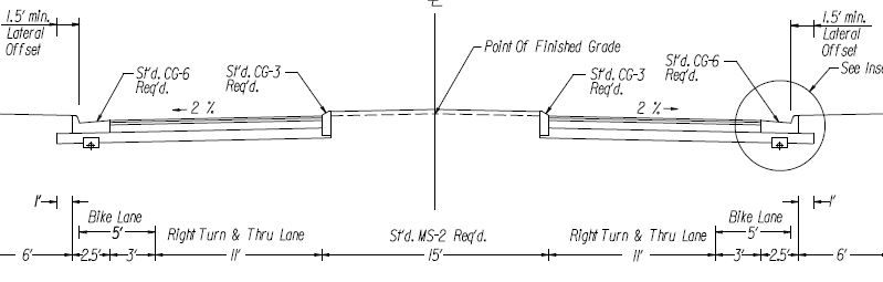
The typical cross-section for 13th Street in the application shows five foot bike lanes and 11 foot travel lanes, with a median island of up to 15 feet. I think there are three ways this misses an opportunity to provide better bicycle facilities for people:
Bike Lanes Should Not Include Gutters
The five foot bike lane includes three feet of bike lane and two feet of gutter. Unless done very well this will create a less smooth facility over time and decrease the usable area to less than five feet. It would be better to have at least four feet of bike lane excluding the gutter pan.
Repurpose Median Width to Better Bike Lanes
Medians can be great and can help create a pleasant and safe environment through tree canopy. But, a 15 foot median is more than is needed for any turning movement of a car in a turn lane and I would prefer larger bike lanes, or striped bike lane buffers, instead of excess median space. The FHWA Bikeway Selection Guide puts this street right on the border between buffered bike lanes and separated bike lanes as a preferred bike facility.
Narrower Lanes for Low Speed
The cross section has 11 foot travel lanes. This is typical of Roanoke, but is likely to make some drivers speed. Going below 11 feet might allow a larger bike lane that didn’t rely on the gutter pan for 40% of its width.
13th Street cross-section with median
13th Street cross-section without median
This is still a pretty low scoring project on Virginia SmartScale, scoring 1.4. That score gives it a state rank of 250 and a district rank of 25. This might be a slight improvement from the last round and may reflect that this is a less ambitious project – because it does not include the bridge over railroad tracks proposed in 2017. That bridge would probably add at least $10 million to the project cost and was one of ten priorities stated by 2020 Mayoral Candidate David Bowers. While the Virginia SmartScale doesn’t see a lot of value in this project, it appears that city leadership may see value due to this second application and was a stated priority by a political challenger.
Update: David Bowers was defeated in the Nov. 3rd election.
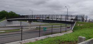
The City of Roanoke has done a great job of investing in its Greenway system and creating greenways that help connect the city. These investments include the impressive Lick Run Greenway bridge over I-581 that connects northwest Roanoke to the Valley View Mall.
To maximize the Lick Run Greenway, one more bridge is needed.
Avoid a Dangerous Intersection
View of Orange Ave Intersection
Close-up of pole with pushbuttons
View of Orange Ave Intersection from trail
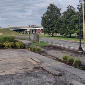
Currently, the Lick Run Greenway has an awkward and dangerous intersection for people biking and walking that separates northwest Roanoke from downtown Roanoke. At the intersection of Orange Ave NW and Gainsboro Rd NW/Burrell St NW people using the Lick Run Greenway must cross between 8 and 10 lanes of traffic using two crosswalk legs with zero pedestrian signal phases or signal faces. There are pedestrian pushbuttons, but they are located on poles in grass, making them difficult to reach if you are biking. Without signal faces, the pushbuttons also do not provide any benefit, unless they subtly change signal timing. Even when used, I have waited more than a minute to be able to cross with the light, which is significant when the segment from Brown-Robertson Park to Downtown takes about 15 minutes according to Google. In my opinion, this intersection is one of the reasons that Google maps does not recommend using the Lick Run Greenway to access Downtown by bike from Brown-Robertson Park.
A bridge over Orange Ave NW to the field of the Booker T. Washington School Administration building could significantly improve the safety and comfort of bicyclists going between downtown and northwest Roanoke on the Lick Run Greenway. There could then be an improved mid-block crossing on Burrell St NW where it is a wide two lane road to connect the bridge to the Lick Run Greenway coming out of Washington Park (Burrell St NW could also use some traffic calming, additional crosswalks to the park, and continuous sidewalks).
Potentially Easier to Build than other Bridges
A bridge at this location would likely be shorter in distance and height than the MLK Bridge downtown. It seems likely that its cost would be less than the $3.5 million to complete that bridge. Its possible that a bridge at this location would cost less than the $800,000 that it took to complete the Lick Run Greenway bridge over I-581. Both sides of Orange Ave are slightly elevated over the roadway, which should help to reduce bridge costs. The city should consider spending enough to incorporate signage that currently overhangs the road at this alignment and to create an appropriate gateway to northwest Roanoke that recognizes its historic significance to the city and how many transportation investments have served to marginalize rather than improve the community.
This bridge would save minutes for every person looking to walk or bike on the Lick Run Greenway between downtown and northwest Roanoke or Valley View Mall. This bridge would make every person making that trip safer by avoiding 6 to 8 lanes that would otherwise need to be crossed and only crossing a lower speed, lower volume road. This bridge would be an investment in reconnecting Roanoke where so many historical investments have made it more difficult for Roanoke’s communities to connect.
Maybe name it after Edward Dudley, America’s first Black ambassador, who grew up on Gilmer Avenue in Roanoke. It seems appropriate that a bridge making connections be named after a man who lived a life of bringing people together through diplomacy and was an avid Bridge card player.
Potential path of bridge using natural elevation
Potential path of bridge
Current Lick Run Bridge over 581
Not in Current Plans
Right now, this investment is not on the Roanoke Greenway Plan or the RVARC Bike Plan as far as I can tell. This investment should be added in the next opportunity to update those plans and be a part of Roanoke’s 2040 Comprehensive Plan. There’s no good way to have a major greenway include an at-grade crossing of a major arterial roadway and 8 to 10 lanes of traffic. A bridge is the only way to truly make the Lick Run Greenway a transportation facility for biking and walking and create a safe and comfortable experience.
There are some projects in the RVARC Bike Plan that could change this intersection, but it is hard to believe that anything less than a bridge will provide a high quality, low-stress, experience. An unspecified improvement on Burrell Street from Orange to Liberty is on the Priority List. An unspecified improvement on Gainsboro Road from Orange to Gilmer is on the Priority List. An unspecified improvement on Orange Avenue from 5th Street to Williamson is on the Vision list. Hopefully, this post helps specify the best possible improvement for the Lick Run Greenway at this intersection – a bridge.
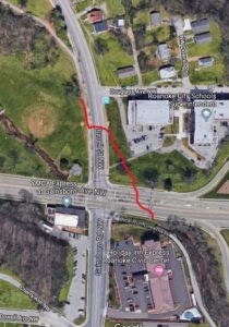
Windsor Ave was a fun road to discover. The first couple of times that I biked from downtown to the Towers shopping center I used Brandon Ave and it was terrifying. Discovering Windsor Ave, and that it allowed me to mostly avoid Brandon Ave was exciting.
As it is, Windsor Ave is a pretty functional bicycle boulevard. It may not be signed as one, or designated as one, or designed in any way as one, but if you find it then it is pretty useful. There is a somewhat parallel signed bicycle route on Maiden Lane and Wasena Ave that allows access to Wasena Village. But there is no question, in my mind, that Windsor Ave provides unique access to Tower, which is otherwise scary and dangerous to access by bike.
What I’d like to see is for Windsor Ave to go from a hidden gem that is functional if you know how to use it to a bicycle route that is recognized by everyone and is designed so that most people use it in the safest manner possible.
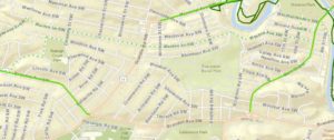
Map of Windsor Ave Bike Route
Current Bike Routes in Wasena
This post is organized going from the Towers Shopping Center to Raleigh Court Park because the improvements close to Towers are much more important to the crucial function of Windsor Ave – providing a low-speed, low-traffic alternative to Brandon Ave in order to access Towers by bike.
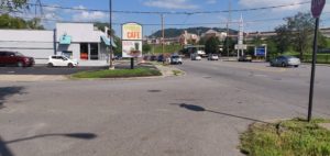
Access to Towers happens at 23rd Street SW. There is a short discontinuity between the end of Windsor and 23rd Street. The way that I deal with this discontinuity is using the driveway that leads to the Tropical Smoothie Cafe to move onto the sidewalk on the north side of Brandon Ave for one block and then line up to cross Brandon Ave at 23rd Street SW in the parking lot of Tech Squared Inc. Since Brandon Ave is the major roadway at this intersection I’ve never found myself not waiting at a red light. If there was oncoming traffic and the light was green when I got to the driveway in front of Tech Squared I would not necessarily expect it to stop for me even though I would have the right of way over left turning traffic.
The intersection of Windsor Ave and Brandon Ave is pretty large and unstructured. That’s probably difficult to change because of Brandon Driveway SW, but I think that there could be a bulb-out or sidewalk along the east side of Windsor Ave added in order to slow people turning onto Windsor without obstructing Brandon Driveway SW. A bulb-out or sidewalk along the east side of Windsor Ave might make people feel better about walking to Towers along Brandon Driveway SW, and might make it easier to transition from Windsor Ave to the sidewalk in front of Tropical Smoothie Cafe while biking. Making that biking transition easier and more likely would be good so that drivers exiting Tropical Smoothie Cafe can expect people. Right now, there are no visible cues that drivers should watch for people biking and walking other than the sidewalk color.
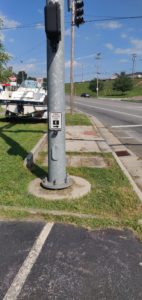
The current sidewalk is not continuous from the corner of Windsor and Brandon to the crosswalk at 23rd Street SW. This crosswalk is the only crosswalk across Brandon Ave for a one mile stretch from Brambleton Ave SW to Franklin Road. Although there is a ADA-accessible curb ramp, it is obstructed by what looks like a recently built traffic signal post. If a person bicycling did not feel comfortable riding through the intersection facing left turning traffic then they’d likely have to dismount to access the curb ramp. A person in a wheelchair would likely have to move into the street against traffic, or cross on the west side of the intersection where there is no painted crosswalk – although “Every Corner is a Crosswalk.” Making this sidewalk continuous would be a great improvement, but is unlikely given the cost of relocating the traffic light post.
Bridging the discontinuity could be improved with signage directing people from 23rd to Windsor. It may also be helpful to have sharrows or other markings at the intersection with 23rd in order to make drivers more aware of bicyclists using this type of crossing as part of a bicycle route.
Intersection of Brandon Driveway and Windsor Ave
Accessible curb cut blocked by traffic light post
Minimal disconnected sidewalk in front of Tech Squared
After that discontinuity the next issue is the concrete diverter at Grace Street SW. I am an unabashed fan of traffic diverters and would love to see Roanoke implement more, but the City should make sure that there is designed room for people biking, walking, pushing strollers, walking dogs, or using wheelchairs to proceed through the diverter. I bike in the drainage ditch right now, but would really like a central cut-through that is at least 3-4 feet wide.
Current concrete diverter
After the diverter the next place I’d like to see changes is at the intersection with Main Street. Green two-stage turn boxes would help draw attention to the bicycle boulevard and encourage people to use a two-stage turn to cross Main Street, which can be much easier and safer when there is traffic as there is no center turn lane or safe place to wait to turn left. This is probably more of a nice to have, but it would be an easy place to implement some infrastructure that I haven’t seen in Roanoke yet.
Other than those changes the biggest question is how to mark the bicycle boulevard so that people know it is there. Right now, Roanoke uses signage and it is easy to miss. There are basically two schools of thought for marking a bicycle boulevard with on-street markings:
I personally would be really interested in seeing edge lane striping on bicycle boulevards in Roanoke. While not common in the United States, it has a good track record abroad and provides a much more continuous experience. One goal of either marking, to me, is to provide assurance to a person bicycling that they are on a route and lanes provide more guidance than occasional markings.
I am intrigued by sharrow-like markings that can be used for wayfinding. There is a NACTO-hosted document on wayfinding sharrows that looks interesting. Somewhat similar is a proposal for wayfinding bicycle dots from Seattle Neighborhood Greenways. Something like that would be an improvement from signage and could be done in a way that leverage Roanoke imagery to provide a local branding to bicycle routes.
One other thing to consider is that there are several T-intersections along Windsor Ave. Traffic calming at those points might be beneficial and VDOT may have some ideas to use.
Sometimes small improvements can make all the difference. This post is a collection of smaller issues that I’ve noticed while riding on Roanoke Greenways. The common theme for many of the potential improvements in this post are that they limit accessibility to a greenway. What could be an access point is instead a barrier.
One issue with small projects is that there may not be a budget for small projects. It can sometimes be easier for an agency to plan and deliver a large project, which might be eligible for grant funding, over a small project, which might be too small to be worth putting the project out to bid for a contractor. This means that small issues can stay unsolved.
My hope with this post is to describe these small issues so that they can perhaps be bundled into larger projects in their relevant areas, be bundled together so that they can more easily access funding, or be solved in any other way.
Norwich Access Improvement
In the 2003 Neighborhood Plan for Norwich the Plan says “Many residents expressed that developing the river for recreational use with better accessibility is a high priority.” At the time of that Plan, there was no Roanoke River Greenway in the area.
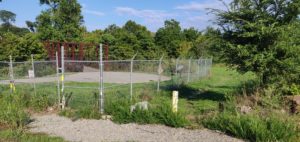
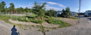
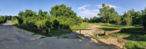
When the Roanoke River Greenway was built, it was not connected to Norwich. Instead a fence separates the residents of Norwich from the Roanoke River Greenway where it is mere feet from the end of Ashlawn Street SW. A post marks a dirt path that people have likely made through accessing the Greenway here. It is a half mile walk, or ride, to the next access point at the current end of the Roanoke River Greenway at Bridge Street SW.
Improving access here could be as easy as removing part of the fence and laying down 10-15 feet of pavement to provide an access point.
Improving access here could also be part of any larger project of repaving in Norwich, if Ashlawn is repaved. Or if sidewalks and gutters were added to the neighborhood, which currently lacks them.
An additional improvement would be striping a crosswalk at the intersection of Ashlawn and Roanoke Ave SW to facilitate a connection between Norwich Park and the Roanoke River Greenway. Creating a good connection there could mean less vehicle traffic for softball games.
A fence prevents access to the Roanoke River Greenway at Ashlawn Street without a walk through grass.
Ashlawn Street lacks a sidewalk and ends at the Roanoke River Greenway.
West End/Hurt Park Access Improvement
At the end of 17th Street SW there is a gate and a dirt patch that turns to mud when there is rain. This could provide an access point for the West End and Hurt Park to the Roanoke River Greenway.
Aside from the dirt/mud pit, this access point is not ideal. To get to it you have to cross a railroad track once if coming from the west and three times if coming from the east. A more direct path through some of the industrial land along Cleveland Avenue SW could help improve access from the West End and Hurt Park.
The closest alternative access point is at Memorial Bridge. From any place west of 16th Street SW, this is likely to be the closest access point to the Roanoke River Greenway. From the intersection of 18th St SW and Patterson Ave SW, a person would save half a mile if they used this access point rather than the one at Memorial Bridge.
Improving access here could be as easy as laying down about 20 feet of paving where there is a mud pit today.
Improving access here could also be part of a larger project to clean up and redevelop the current industrial uses along Cleveland Ave, particularly if a connection could be made to Campbell Ave SW or 16th Street SW.
View from 17th Street looking toward Roanoke River Greenway
Large dirt patch seen from Roanoke River Greenway looking toward 17th Street
Best Buy Access Improvement
When the Lick Run Greenway crests over I-581 toward Valley View Mall, people are greeted by a sturdy fence that runs along the southwestern edge of the Best Buy parking lot. Eventually that fence ends and the parking lot opens up, but people biking or walking on the Greenway have to continue another thousand feet or so to the signalized intersection to turn into the parking lot.
A ramp and about 5-10 feet of paving could let people access the parking lot without having to deal with the signalized intersection. That would be a great improvement as traffic is heavy at the intersection, making it an uncomfortable place to cross. There is bike parking by the Target and a ramp would ideally be placed to guide people to that bike parking without too much riding through the parking lot.
Lick Run Greenway at Target/Best Buy
Gilmore/Patton Access Improvements
At Wells Ave SE, the Lick Run Greenway starts to become a real trail. Unfortunately for the people who live along Gilmore Ave NE and Patton Ave NE, there is no ramp along 2nd St SE that gives them access to the Lick Run Greenway.
It is possible to cut through the parking lot of the Anstey Hodge Advertising Group and access the Lick Run Greenway without getting off your bike, or scooter, or wheelchair, or other mobility device. But, cutting through a parking lot is not an ideal solution and does not recognize that people deserve a public right of way to a public space.
For an area that has suffered so much due to transportation projects designed to tear up the community of historic Gainsboro, the least that can be done is to put a curb ramp and about 3-5 feet of trail so that people can access the trail without using the parking lot.
Solid curb at Gilmer Ave
Disturbed plants where people might be accessing trail through parking lot
Norris Dr NW Access Improvement
At Norris Drive NW the Lick Run Greenway is accessible from the cul-de-sac end of Norris Drive NW. For residents of Northwest Roanoke who are on the south side of Lick Run the next closest access to the Lick Run Greenway is at Brown-Robertson Park along 10th Street about a mile away. This is access point is the furthest western access point on the south side of I-581. For all these reasons, this should be an important access point as it has the potential to serve a large community in Northwest Roanoke who have no closer access point.
On either side of the bridge over Lick Run at this access point is a mix of gravel, dirt, and vegetation. When it rains, this area can get muddy and stay muddy. There is also the possibility of flooding, which is not exactly uncommon in Roanoke. Improving this access point is straightforward. It would require a paved path on either side of the existing bridge to provide a more consistent surface. My guess is that it would be 20 to 30 feet of path in total. It is possible that some stormwater management would add to the cost and complication of an improvement here, but that is only based on seeing pooled water in the cul-de-sac.
The area to the west of this access point appears to have a complicated development history and the City of Roanoke should improve this access point rather than wait for potential development to provide another access point for Northwest Roanoke or to improve this access point.
I don’t know if the potential for development has prevented Roanoke from investing in this area, but there are some oddities in the neighborhood in anticipation of some development. Andrews Road NW is incredibly wide, probably wide enough for six lanes of traffic or more. It seems likely that some of that width could be used to create a cycle track that connects this Lick Run Greenway access point to Kennedy Park, which has an extensive pathway system. Creating a connection there could also be as easy as adding wayfinding so that more people are aware that the Lick Run Greenway can be found here.
Roanoke’s 2017 Downtown Plan identifies the many one-way streets downtown as a barrier to a thriving downtown. The Plan says:
“Restoring two-way traffic is a tried and true revitalization strategy. Salem and Campbell Avenues were both converted back to two-way in the early 2000s, with considerable objection. Since then, downtown has prospered and many now support the changes after initially opposing the idea.
At present, 1st Street, and Church, Luck, and Kirk Avenues are the significant one-way streets in downtown. Conversion to two way streets would greatly benefit: public safety… property values… and overall livability.” (emphasis added)
The plan goes on to suggest some ideas for changes but makes clear that final decisions should be coordinated with adjacent businesses and property owners. In this blog, I’m going to lay out what I would like to see so that the city, adjacent businesses and property owners, and anyone else can understand my experience with bicycling downtown and how it is affected by one-way streets, focusing on the one-way streets identified as significant in 2017.
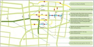
Downtown Circulation Improvements from 2017 Downtown Plan
Proposed Changes to improve bicycling in downtown Roanoke
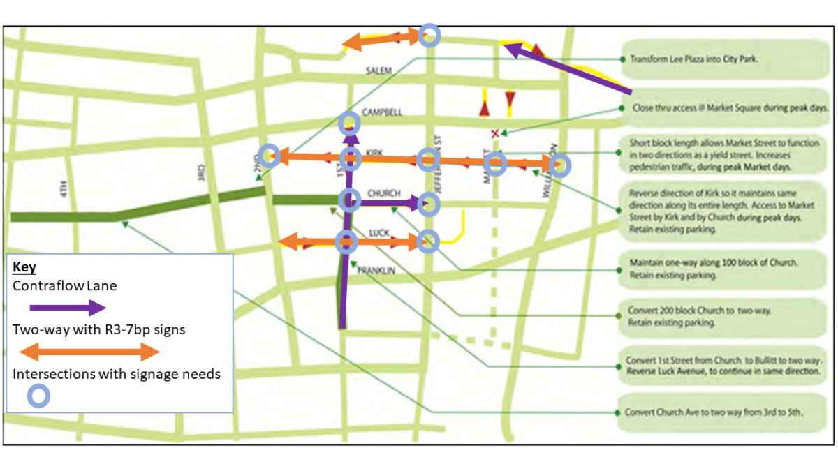
1st Street
I typically approach 1st Street from Luck Avenue as I ride into downtown. As 1st Street is currently a one-way street heading south, away from downtown, 1st Street acts as a barrier for me and directs me away from my destination. It would be a great improvement to make 1st Street two-way for bicycle traffic.
There is plenty of room for an unprotected contraflow lane on 1st Street. An unprotected contraflow lane would not be ideal, but would be cheap and a huge improvement for cycling circulation. With a contraflow lane on 1st Street bicyclists should be directed to follow pedestrian signals, which exist at every signalized intersection on 1st Street. A contraflow lane would make the most sense on the East side of the Street from Bullitt Ave SW to Campbell Ave, where 1st Street becomes two-way for one block before dead ending in the MLK Bridge. It is possible that parking could be shifted to protect the contraflow lane, and if there is a space for that on 1st Street or any other street downtown then it should be done if possible.
Along 1st Street, it would be best to have bicycle signals for the contraflow lane. But, to save money, the city should consider using R9-5 signs that direct people biking to use pedestrian signals. This would save a significant amount of money associated with a contraflow lane and would allow the city to move forward with a more provisional design while larger changes to downtown circulation are discussed. All of the signalized intersections on 1st Street through downtown: 1st and Salem Ave, 1st and Campbell, and 1st and Church, have pedestrian signals that could be supplemented by R9-5 signs in order to provide direction to bicyclists using a contraflow lane.
Church Avenue
My big issue with Church Ave is that it has Breadcraft on it, and I really like Breadcraft. Since Church Ave is one-way, I always have to go past Breadcraft and then circle back around to it. In the 2017 Downtown Plan, the suggested changes don’t include making the block with Breadcraft two-way. That block of Church Ave between 1st Street and Jefferson Street is narrow and hard to make two-way for cars without removing parking from one side. However, there should be room for an unprotected contraflow lane on the South side of the street. That would allow easy access to Breadcraft from 1st Street. As with 1st Street, bicyclists should be directed to follow the pedestrian signal at Jefferson Street.
While a contraflow lane or two-way traffic from 5th Street to 1st Street could be nice, it’s not a likely cycling route for me. Making those blocks two-way is in the 2017 plan and would be an okay improvement for biking if that change included bike lanes.
Luck Avenue
Luck Avenue is probably my primary access road to and from downtown. When I head toward downtown, I have to choose between breaking the law by continuing straight along Luck Avenue or detouring to a poorly maintained alley or Franklin Road. When I head away from downtown, I have to choose between continuing straight on Luck Avenue or detouring to Franklin Road. Franklin Road, in either case, involves an uphill climb and often waiting at a signal in order to turn onto a higher traffic road with no bike lanes.
Making Luck Avenue better for biking can be easy. All it takes is the use of r3-7bp signs that say “Except Bicycles” so that the one-way restriction on Luck Avenue does not apply to people biking. It would take three signs, two on either side of 1st Street and one on the west side of Jefferson Street.
Kirk Avenue
Kirk Avenue is pretty amazing to ride on. It’s well designed, it’s low traffic, it has a great downtown vibe. The problem is that it only allows bicycle traffic one-way. Worse, it’s not consistently one-way. The 2017 Plan suggests making it one-way consistently with all traffic going west.
Kirk Avenue is low traffic, so it could be made two-way for bicycle traffic with r3-7bp “Except Bicycles” signs. By my count, it would take four of them to go from 2nd Street to Market Street, and five to go to Williamson Road.
Kirk Avenue is also likely wide enough for an unprotected contraflow lane on the South side of the road. The intersections on Kirk Avenue are not signalized so there would need to be stop signs added at each intersection.
Bonus one-way street: Norfolk Avenue
In the 2017 Plan, Norfolk Avenue didn’t get identified as a significant one-way street and no suggests changes were included for Norfolk Avenue.
In my experience, Norfolk Avenue is very low traffic and an amazing bypass route of downtown when I am biking. It is fun to head past the Virginia Museum of Transportation, bike between the concrete bollards, head along the train tracks along the Railside Linear Walk, and past the Taubman Museum. It is a relief to end the sprint west along Campbell Ave where there are no bike lanes by turning off on Norfolk and cautiously proceeding against traffic, when there is traffic.
With the right changes, Norfolk Ave could be a great place to bike. It could be a recreational diversion for people. It could be a bypass for people who need to bike around downtown. It could be the most separated, low-traffic, and comfortable route for people going to and from downtown. With the transit station moving to the West End in from the of Virginia Museum of Transportation, this route would provide a signal-free, mostly intersection-free, route for scooters and bikes between downtown and the transit center.
Potential Changes to Norfolk Ave
The necessary changes are not that expensive or complicated, from West to East they are:
Putting a R3-7bp “Except Bicycles” sign at Jefferson Street for bicycle traffic coming from the East
Striping a contraflow lane on the north side of Norfolk Ave from Market Street to Campbell Ave
Some nice features would be:
Repaving the area by the concrete bollards, and providing signage that this is a bike route
Striping bike lanes, sharrows, advisory bike lanes or some other bike facility from 5th Street to the concrete bollards
A convex mirror at the west end of the Railside Linear Walk
A median island at the intersection of Norfolk Avenue and Campbell Avenue to provide protection to bicyclists entering the contraflow lane and make cars turning left onto Campbell Avenue approach the intersection more perpendicularly