One of the issues that people face while biking in Roanoke is moving between the different parts of the city and to surrounding communities. There are major barriers for anyone who wants to bike from southwest Roanoke to Northwest (mainly large and difficult intersections along Orange Ave), and the city of Roanoke is effectively segregated by infrastructure in many ways.
Currently it is fairly common and easy for people to bike from Downtown Roanoke to Downtown Vinton or vice versa. But, if a project currently planned for 13th street goes through as planned it will make this trip more difficult for people biking.

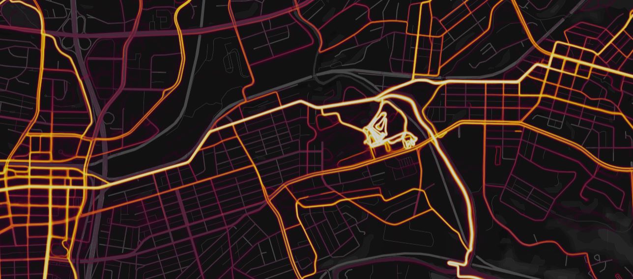
The biggest problem with the proposed project for 13th Street connecting to Hollins is a large roundabout at Wise Ave. Wise Ave is the bright east-west route in the Strava heat map above. It connect downtown Roanoke to downtown Vinton and both to the cyclocross course at Fallon Park , which hosts the annual GoCross race.
There are three major problems with the proposed roundabout designed for the intersection of 13th and Wise Ave:
- It is a multi-lane roundabout. While Wise is otherwise a two lane road, it will expand to four lanes at the roundabout. 13th Street going north will similarly go from two lanes to four at the roundabout. In both cases, a person riding through the roundabout will have to take the lane as drivers see more open space.
- It has slip lanes which encourage drivers to maintain speed through the roundabout. One potential benefit of roundabouts is that they slow drivers at intersections, reducing the chance of crashes that cause serious injury or death. By providing slip lanes for people turning right at the roundabout, the design encourages higher speeds and makes it more difficult for slower traffic, like people biking and walking, to navigate. There is an existing roundabout at Riverland Road and Bennington Street SE that has slip lanes and is similar in design. While the Roanoke River Greenway connects to the Garden City Greenway through this roundabout, the connection is not a path width and has several difficult angles.
- Roundabout design guidance in the United States says to not include bike lanes through a roundabout because traffic must cross the bike lanes. There is also no plan to provide a path or trail alternative or provide an alternate bike route. The larger project actually cuts off a low traffic bike route along Dale Avenue that shows up on Google maps, but not the Roanoke bike plan. This means all people who want to bike from Roanoke to Vinton or vice versa will have to take the lane through this high speed multi-lane roundabout with no bike lanes or other accommodations.
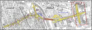
The entire project has two roundabouts and significantly expands 13th Street.
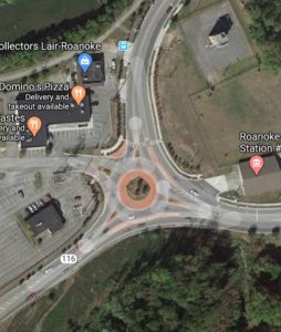
This is the existing Riverland Road roundabout with slip lanes.
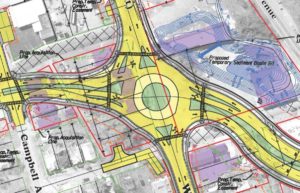
This is the roundabout proposed in 2017 for Wise and 13th with slip lanes.
Overall, the 13th Street and Hollins Road project as proposed would make a significant bicycle route more difficult to navigate and less safe. The supposed upside is improved traffic flow, but the project proposal estimates that traffic will double from current levels. While Roanoke is a growing city, it is growing because of its outdoor appeal, not its lack of traffic congestion. The proposed project is estimated to cost $37 million and much of that cost is likely due to it being designed for a level of traffic that may never appear, much like 13th Street south of Jamison Avenue.
I sincerely hope that this project never comes to pass. When Roanoke applied for state funding through the Smartscale process it scored poorly. When it was scored in 2017, it was 38th out of 50 in the Salem VDOT district and was in the bottom half of all projects in the state.
This is a $37 million project with total costs that will likely be more than $60 million and will make it harder for people to bike between Roanoke and Vinton. While I am sure there are good reasons that it was developed, this is a bad project for people who bike and likely a waste of money for the taxpayers of Roanoke and Virginia.