Windsor Ave was a fun road to discover. The first couple of times that I biked from downtown to the Towers shopping center I used Brandon Ave and it was terrifying. Discovering Windsor Ave, and that it allowed me to mostly avoid Brandon Ave was exciting.
As it is, Windsor Ave is a pretty functional bicycle boulevard. It may not be signed as one, or designated as one, or designed in any way as one, but if you find it then it is pretty useful. There is a somewhat parallel signed bicycle route on Maiden Lane and Wasena Ave that allows access to Wasena Village. But there is no question, in my mind, that Windsor Ave provides unique access to Tower, which is otherwise scary and dangerous to access by bike.
What I’d like to see is for Windsor Ave to go from a hidden gem that is functional if you know how to use it to a bicycle route that is recognized by everyone and is designed so that most people use it in the safest manner possible.
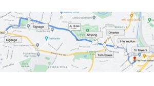
Map of Windsor Ave Bike Route
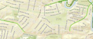
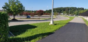
Current Bike Routes in Wasena
This post is organized going from the Towers Shopping Center to Raleigh Court Park because the improvements close to Towers are much more important to the crucial function of Windsor Ave – providing a low-speed, low-traffic alternative to Brandon Ave in order to access Towers by bike.
Access to Towers happens at 23rd Street SW. There is a short discontinuity between the end of Windsor and 23rd Street. The way that I deal with this discontinuity is using the driveway that leads to the Tropical Smoothie Cafe to move onto the sidewalk on the north side of Brandon Ave for one block and then line up to cross Brandon Ave at 23rd Street SW in the parking lot of Tech Squared Inc. Since Brandon Ave is the major roadway at this intersection I’ve never found myself not waiting at a red light. If there was oncoming traffic and the light was green when I got to the driveway in front of Tech Squared I would not necessarily expect it to stop for me even though I would have the right of way over left turning traffic.
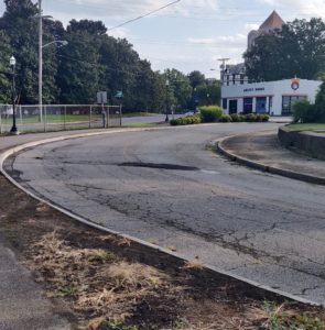
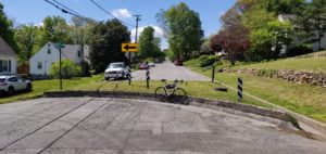
The intersection of Windsor Ave and Brandon Ave is pretty large and unstructured. That’s probably difficult to change because of Brandon Driveway SW, but I think that there could be a bulb-out or sidewalk along the east side of Windsor Ave added in order to slow people turning onto Windsor without obstructing Brandon Driveway SW. A bulb-out or sidewalk along the east side of Windsor Ave might make people feel better about walking to Towers along Brandon Driveway SW, and might make it easier to transition from Windsor Ave to the sidewalk in front of Tropical Smoothie Cafe while biking. Making that biking transition easier and more likely would be good so that drivers exiting Tropical Smoothie Cafe can expect people. Right now, there are no visible cues that drivers should watch for people biking and walking other than the sidewalk color.
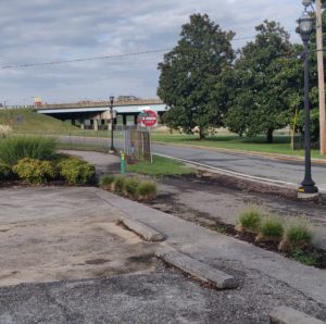
The current sidewalk is not continuous from the corner of Windsor and Brandon to the crosswalk at 23rd Street SW. This crosswalk is the only crosswalk across Brandon Ave for a one mile stretch from Brambleton Ave SW to Franklin Road. Although there is a ADA-accessible curb ramp, it is obstructed by what looks like a recently built traffic signal post. If a person bicycling did not feel comfortable riding through the intersection facing left turning traffic then they’d likely have to dismount to access the curb ramp. A person in a wheelchair would likely have to move into the street against traffic, or cross on the west side of the intersection where there is no painted crosswalk – although “Every Corner is a Crosswalk.” Making this sidewalk continuous would be a great improvement, but is unlikely given the cost of relocating the traffic light post.
Bridging the discontinuity could be improved with signage directing people from 23rd to Windsor. It may also be helpful to have sharrows or other markings at the intersection with 23rd in order to make drivers more aware of bicyclists using this type of crossing as part of a bicycle route.
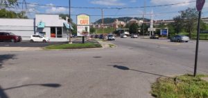
Intersection of Brandon Driveway and Windsor Ave
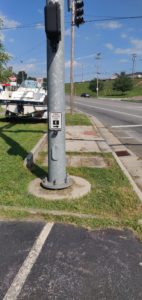
Accessible curb cut blocked by traffic light post

Minimal disconnected sidewalk in front of Tech Squared
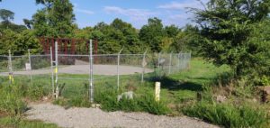
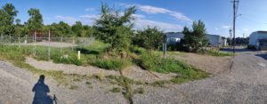
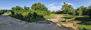
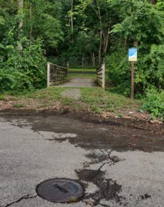
After that discontinuity the next issue is the concrete diverter at Grace Street SW. I am an unabashed fan of traffic diverters and would love to see Roanoke implement more, but the City should make sure that there is designed room for people biking, walking, pushing strollers, walking dogs, or using wheelchairs to proceed through the diverter. I bike in the drainage ditch right now, but would really like a central cut-through that is at least 3-4 feet wide.
After the diverter the next place I’d like to see changes is at the intersection with Main Street. Green two-stage turn boxes would help draw attention to the bicycle boulevard and encourage people to use a two-stage turn to cross Main Street, which can be much easier and safer when there is traffic as there is no center turn lane or safe place to wait to turn left. This is probably more of a nice to have, but it would be an easy place to implement some infrastructure that I haven’t seen in Roanoke yet.
Other than those changes the biggest question is how to mark the bicycle boulevard so that people know it is there. Right now, Roanoke uses signage and it is easy to miss. There are basically two schools of thought for marking a bicycle boulevard with on-street markings:
- Edge Lane Striping (also known as Advisory Bike Lanes)
- Shared Lane Markings (Sharrows)
I personally would be really interested in seeing edge lane striping on bicycle boulevards in Roanoke. While not common in the United States, it has a good track record abroad and provides a much more continuous experience. One goal of either marking, to me, is to provide assurance to a person bicycling that they are on a route and lanes provide more guidance than occasional markings.
I am intrigued by sharrow-like markings that can be used for wayfinding. There is a NACTO-hosted document on wayfinding sharrows that looks interesting. Somewhat similar is a proposal for wayfinding bicycle dots from Seattle Neighborhood Greenways. Something like that would be an improvement from signage and could be done in a way that leverage Roanoke imagery to provide a local branding to bicycle routes.
One other thing to consider is that there are several T-intersections along Windsor Ave. Traffic calming at those points might be beneficial and VDOT may have some ideas to use.