It’s been awhile since I’ve posted. Part of that lapse was working on a grant proposal for Roanoke Outside this spring. That grant proposal was one of over 3,000 for an AARP Community Challenge Grant and one of over 3,000 that were not funded.
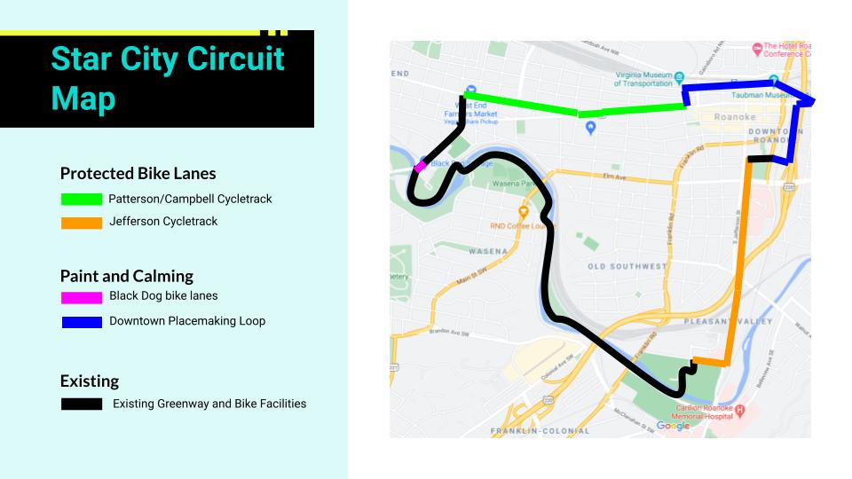
My grant proposal was called the Star City Circuit. The Star City Circuit is a proposal for the largest pop-up bike network in Virginia history, connecting 6 miles of Roanoke with protected two-way bike lanes, existing bike infrastructure like the Roanoke River Greenway, and a downtown route of low-traffic streets. In concept, it is a demonstration of the Downtown Roanoke Urban Loop from the 2017 Downtown Neighborhood Plan and which I blogged about a year ago in July 2020.
My grant proposal for Roanoke Outside asked AARP for $10,000 to implement a one-day demonstration project. While the AARP email informing Roanoke Outside of not getting the grant did not provide feedback, my guesses for why the proposal did not receiving funding would be:
- There was no local match for the $10,000 ask. Other grant programs, like the People For Bikes Community Grant, will not fund proposals asking for more than 50% of the funding required. For future success, local fundraising will likely be key.
- Roanoke does not have a record of pop-up demonstration projects. While Roanoke does sometimes close streets for events, has a great chalk-up the city scene, and has an admirable record for safe street reconfigurations, there is little record of temporary street changes. Going from no record to the largest pop-up in Virginia history is a big jump.
- The proposed design was not fully vetted by important stakeholders. Major sections of the proposed project pass directly by law enforcement agency offices and the largest employer in the region, Carilion Clinic, and I didn’t secure letters of support from either. Getting the support of both will likely be important for future success.
So, what is the Star City Circuit?
Well, as one project it is 6 miles of connected Greenway, two-way protected bike lanes, low-traffic streets, contraflow lanes, signs, and improved intersections. But, it’s probably best described as three improved corridors and one major intersection improvement.
First, the Star City Circuit is not possible without Roanoke’s existing bike infrastructure. It uses existing bike infrastructure for about 43% of its length, primarily the Roanoke River Greenway between Black Dog Salvage at Memorial Bridge and the River’s Edge Sports Complex.
Jefferson Street Corridor
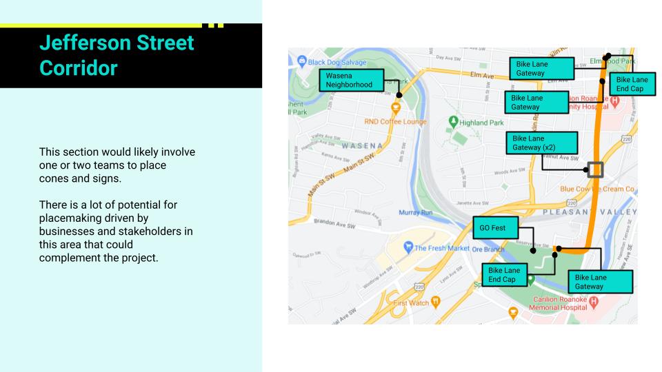
The easiest to implement improved corridor is Jefferson Street between Elmwood Park and River’s Edge. In this section, Jefferson Street is a road that meets federal criteria for a road diet – meaning that an existing travel lane can be repurposed without much negative effect on congestion – and that congestion may even be improved by converting an existing travel lane into a center turn lane. For the purpose of the Star City Circuit, and the proposed Downtown Urban Loop, this means that Jefferson Street can have its west-most lane converted to a two-way protected bike lane. With enough traffic cones, the west-most lane can be dedicated to people biking, walking, and scooting. At Reserve Road, this lane would use the slip lane to make a fully separated turn towards River’s Edge Park before connecting with the Roanoke River Greenway. By connecting River’s Edge Park, South 16 Apartments, and the Virginia Tech-Carilion Clinic Fralin Biomedical Research Institute to downtown, this is a potentially transformative link on its own.
Downtown Corridor
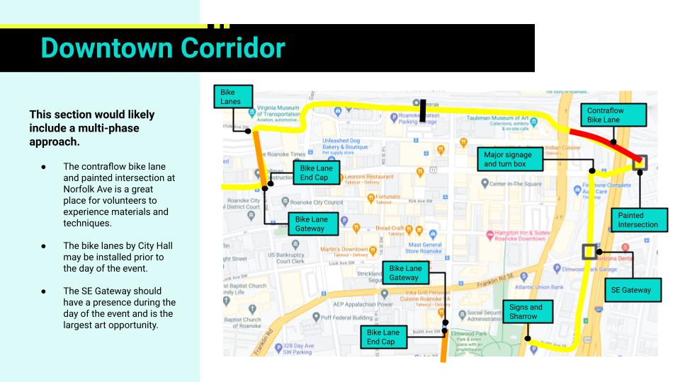
The next corridor is not, strictly speaking, a corridor. But it is the section of low-traffic streets from 3rd Street SW to 3rd Street SE that allows the Star City Circuit to navigate downtown without causing much disruption to downtown. The most direct route would use Campbell Avenue and Market Street to create a loop, but that would require repurposing probably 50-100 parking spaces downtown. Instead, to avoid displacing parking, the Star City Circuit proposal uses a somewhat meandering route that avoids car traffic. Going left-to-right, the proposal begins at Campbell Avenue and 3rd St SW, then goes on 3rd St SW towards the Virginia Museum of Transportation before turning onto Norfolk Ave SW and continuing on Norfolk Ave SW until it hits Campbell Ave SE, taking a quick right turn on Campbell Ave before a left onto 3rd St SE, then following 3rd St SE until it turns into Bullitt Ave SE and then the Elmwood Art Walk. This meandering route has the advantage of including the future downtown transit center, low-traffic on all segments except the quick half-block on Campbell Ave, and great potential for future development.
Campbell-Patterson Corridor
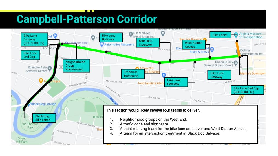
The final corridor is the most complicated and goes from 13th Street SW to 3rd Street SW. In those ten blocks there are several major challenges that require careful attention as a pop-up project and as a long-term project. The Star City Circuit proposal attempts to balance the issues, but this is a corridor where experience and feedback from the pop-up will be critical to the long-term solutions.
The biggest challenge in this corridor is the Y-intersection of Campbell Ave and Patterson Ave, where a man died in a motorcycle crash in 2020. This intersection has relatively higher traffic, a high-speed unprotected left turn, and an elevation change that creates visibility issues. The way that the Star City Circuit deals with this challenging intersection is by repurposing the northmost lane on Patterson Ave to avoid conflicts at the intersection and then switching sides of the road at 6th Street in order to better use space on the south side of Campbell Ave. The preference of the Mountain View Neighborhood Association, located on the West End of Campbell Ave, would be to use Campbell Ave the entire way. However, that is only possible by taking all of the parking spaces from 13th Street SW to 6th Street SW or making Campbell Ave a one-way street for that segment. Either of those solutions is complicated for a pop-up, but either could be possible in the long-term.
Another major challenge for the 13th Street SW to 3rd Street SW corridor, is the complex of the Roanoke City Jail, Roanoke City Sheriff Office, and Roanoke City Police Department between 4th Street SW and 3rd Street SW. In this section, there are about 8-10 parking spots reserved for law enforcement that likely need to be maintained for any demonstration project and for the long-term. The Star City Circuit deals with this by creating a parking protected bike lane that preserves these parking spots – the first parking protected bike lanes in Roanoke, and maybe the Roanoke-Alleghany Valley. While complicated to implement as a pop-up, this will allow the community to interact with, and react to, a new type of bike infrastructure that may be used in the future.
SE Roanoke Gateway Intersection
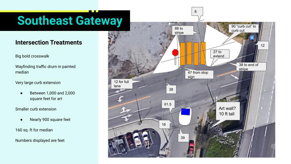
SE Gateway Measurements
SE Gateway Concept
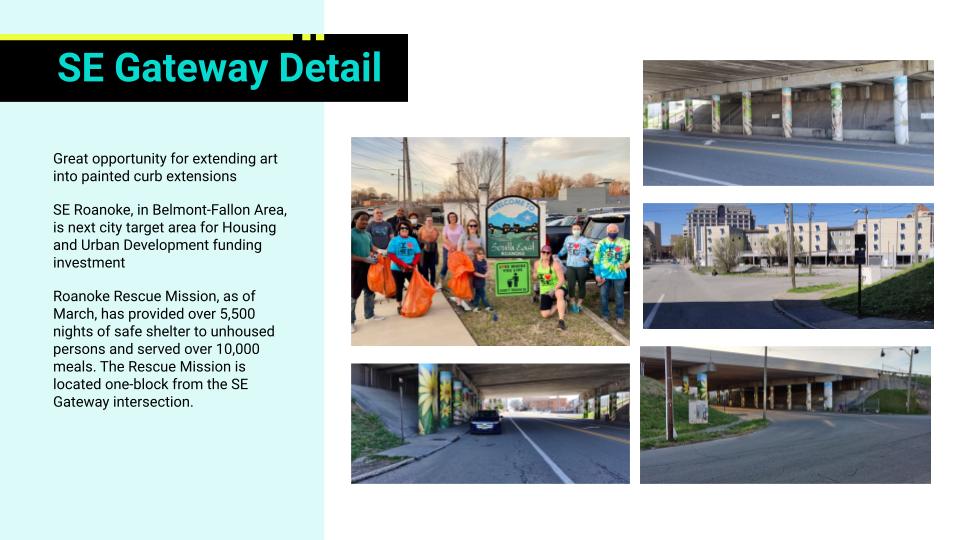
The one major intersection improvement that deserves attention is at 3rd Street SE and Tazewell Ave SE. This intersection is currently between a wide four-lane road in Tazewell Ave SE and a smaller two lane road in 3rd Street SE. There are sweeping corners and no crosswalks despite a bus stop and good foot traffic as the closest access between SE Roanoke and downtown. In the Star City Circuit proposal, this intersection is calmed through large painted curb extensions, crosswalks, and small median islands. It is also an ideal intersection for a pop-up tent and potential future development.
And, that’s the essence of the proposal. As far as I can tell, if this proposal is implemented it would be the largest pop-up bike network in Virginia history and likely one of the 5 or 10 largest in US history. While there are some complicated parts, there’s nothing stopping this from being implemented.
Next steps for this project are still in flux. I’m looking to do local fundraising and I’m looking to do a smaller project to test pop-up materials such as temporary street paint. If you’re interested in this project, please reach out!