Quick Feedback
Roanoke County is soliciting feedback on proposals for bicycle and pedestrian improvements on Starkey and Ogden Roads adjacent to Tanglewood Mall. The Tanglewood Mall area has a long-term plan to be redeveloped as 419 Town Center, which includes improving the bicycle and pedestrian access and experience in the surrounding area.
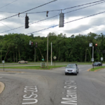
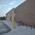
There’s no sugar coating that it is currently very difficult to walk or bike to Tanglewood Mall. I have biked nearly 80% of the roads in the City of Roanoke and hundreds of miles in the surrounding area, but I have not yet chosen to bike to Tanglewood Mall. The closest I have gotten is the Roanoke city side of the 220 interchange where the bike lanes give way to sharrows while you go under 220 and the end of Winding Way Road where it intersects with Ogden Road. The intersection of Winding Way Road and Ogden Road is about .2 miles and 220 is about .7 miles from the project area of this public comment opportunity.
Roanoke County is asking for comments on their proposal and they way they are accepting comments has three major components:
- Ranking a list of potential improvements for Starkey road
- Ranking a list of potential improvement for Ogden road
- An open-ended comment box
Here is how I approached and answered those options. Roanoke County is accepting comments until March 15th.
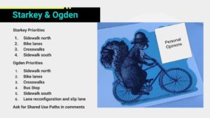
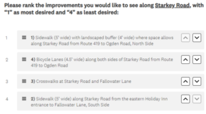
Ranking a list of potential improvements for Starkey road
The section of Starkey Road in this project area is a short section that connects two higher volume roads on either side. It has a major destination in a shopping center anchored by Food Lion, with several restaurants such as Ben Gui Sushi and Bellacino’s that I think are worth the visit to this area. From what I can tell, all of the immediately adjacent development to Starkey Road is commercial development.
There are four options provided to rank and here they are listed in the order that I ranked them:
- Sidewalk with landscaped buffer on north side of Starkey Road wherever space allows
- Bicycle lanes along both sides of Starkey Road
- Crosswalks at Starkey Road and Fallowater Lane
- Sidewalk on south side of Starkey Road
I think the sidewalk on the north side of Starkey Road is the biggest proposed improvement on Starkey Road. Providing an ideally continuous sidewalk on one side of Starkey Road would transform the safety and ability of walking along this corridor. It would make walking a viable option where it currently is not.
The bicycle lanes proposed would be consistent with the existence of bicycle lanes on surrounding roads, but as basic painted bike lanes amidst a sea of auto-oriented streets they feel more like a gesture toward multimodalism than a transformative facility. To get here and use them, a bicyclist would have already had to navigate extremely challenging circumstances and will only receive a slightly better experience thanks to the painted bike lanes proposed.
The crosswalks proposed at Starkey Road and Fallowater Lane are a great addition to this corridor and really reinforce the northside sidewalk proposed. I ranked them lower than the proposed bike lanes mostly because they are such a low-cost feature that it’d be surprising if they were not provided.
The sidewalk proposed for the south side feels fairly compromised due to its limited length so I ranked it lowest.
Ranking of transportation priorities
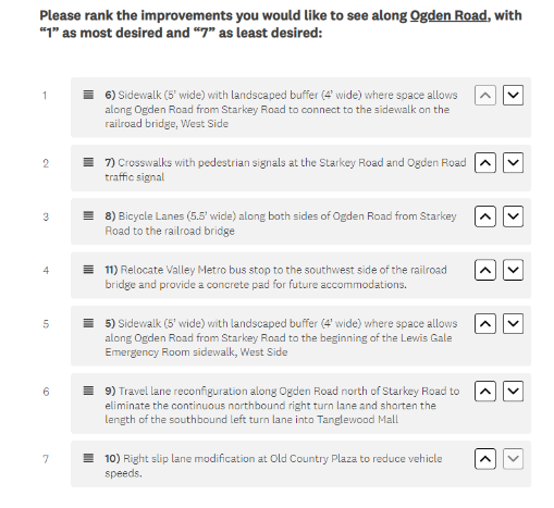
Ranking a list of potential improvement for Ogden road
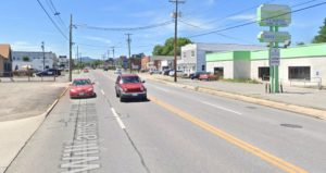
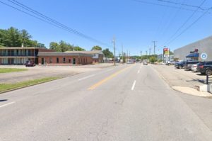
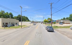
The section of Ogden Road in this project area runs between the shopping center with Food Lion and Tanglewood Mall. It is a higher volume road with a 25 mile per hour speed limit that is likely rarely followed. It gets pretty wide, with five lanes at some points including turn lanes.
There are seven options provided to rank and here they are listed in the order that I ranked them:
- Sidewalk with landscaped buffer on west side of Ogden Road wherever space allows from Starkey Road north to the railroad bridge
- Crosswalks with pedestrian signals at the Starkey Road and Ogden Road traffic signals
- Bicycle lanes along both sides of Ogden Road
- Relocate Valley Metro stop southwest of railroad bridge with concrete pad for future improvements
- Sidewalk with landscaped buffer along west side of Ogden Road wherever space allows from Starkey Road south to existing sidewalk at Lewis Gale ER
- Travel lane reconfiguration on Ogden Road
- Slip land modification at Old Country Plaza
The proposed sidewalk on the west side of Ogden Road between Starkey Road and the railroad bridge would connect to an existing sidewalk built into the railroad bridge. While the existing sidewalk is relatively narrow, connecting to it is important to be able to connect to residential areas on the north side of the railroad bridge, including potentially to the City of Roanoke via Winding Way Road. To me, this proposed sidewalk section is also the major justification for the crosswalks, slip lane modification, and bus stop improvements proposed, so it is more important than those individual improvements.
The proposed crosswalks with pedestrian signals are very important for providing safer access to Tanglewood for people walking or biking on a sidewalk. It is honestly a bit hard to see how Roanoke County would implement this project and not provide these crosswalks, but they don’t exist currently and they wouldn’t connect to any sidewalks unless sidewalks are implemented as part of this project.
Like the proposed bicycle lanes on Starkey Road, the bicycle lanes proposed for Ogden Road would be consistent with the existence of bicycle lanes on surrounding roads, but as basic painted bike lanes are unlikely to significantly impact the number of people who would feel safe biking in this area. I rank them highly to voice support for bicycle improvements, but realistically these bike lanes are as likely to be used as those that currently exist along Electric Road where most people would likely choose to bike on the sidewalk.
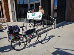
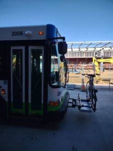
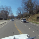
Relocating the bus stop is a great idea because the existing bus stop is a sign stuck into grass with nothing connecting to it. Relocating the bus stop along a sidewalk would be a huge improvement and the proposed pad is looking forward to future improvements, like a shelter, that make waiting for a bus much better. Relocating the bus stop does not address creating a continuous sidewalk for people accessing it from residences north of the railroad bridge, but that is unfortunately outside of the scope of this project.
There’s a good argument that I’m under-ranking the proposed sidewalk from Starkey Road to the Lewis Gale ER. It is an important link to an existing sidewalk in the area and ties into the sidewalk along Electric Road. I rank it lower because it is a relatively short segment and it would be surprising if the county did not pursue it whereas the bicycle lanes and bus stop relocation feel easier for the county to not pursue absent positive feedback.
I rank the travel lane and slip lane modifications at the bottom because they are less about biking and walking improvements. If there was more information on the slip lane modification then I might rank it higher.
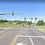
View of Bus Stop on Ogden Road
Transportation Priorities for Ogden Road
Open-ended comment box
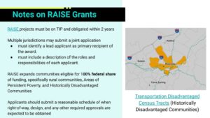
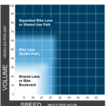
In the open-ended comment box I clarified my support of bicycle lanes in this study area by saying that they are unlikely to significantly improve bicycling in a way that encourages more people to bike in this area. According to the Virginia Department of Transportation, about 7,400 vehicles use Ogden Road each day which according to Federal Highway Administration guidance suggests a separated bike lane or shared use path would be the recommended bicycle facility for Ogden Road. While my ranking shows support for bicycle lanes, my true preference for bicycle facilities in this study area would be converting the proposed sidewalks to shared use paths with minimum widths of at least 12 feet.
I think it was a major oversight that Roanoke County chose painted bike lanes for Electric Road instead of a shared use path along its north side. The painted bike lanes on Electric Road are intimidating to ride on and do not meet modern guidance. Continuing to use painted bike lanes in order to be consistent with those past choices only continues the error.
We are unfortunately kind of stuck with bad bicycle facilities to get to and around Tanglewood Mall. Modern guidance would recommend separated bike lanes or shared use paths along Franklin in the city of Roanoke and to Tanglewood as it becomes Electric Road, but the county likely relies on outdated AASHTO standards that are over a decade old. Unfortunately, painted bike lanes are the current facility within the city and along Tanglewood Mall. Painted bike lanes are also incorporated in future designs for a diverging diamond interchange between 220 and Electric Road. This is a failure of vision to create true bicycle connections that serve people of all ages and abilities and the sooner we can start addressing it the better.
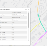
VDOT Traffic Volumes
FHWA Bikeway Selection Guidance