Sometimes small improvements can make all the difference. This post is a collection of smaller issues that I’ve noticed while riding on Roanoke Greenways. The common theme for many of the potential improvements in this post are that they limit accessibility to a greenway. What could be an access point is instead a barrier.
One issue with small projects is that there may not be a budget for small projects. It can sometimes be easier for an agency to plan and deliver a large project, which might be eligible for grant funding, over a small project, which might be too small to be worth putting the project out to bid for a contractor. This means that small issues can stay unsolved.
My hope with this post is to describe these small issues so that they can perhaps be bundled into larger projects in their relevant areas, be bundled together so that they can more easily access funding, or be solved in any other way.
Norwich Access Improvement
In the 2003 Neighborhood Plan for Norwich the Plan says “Many residents expressed that developing the river for recreational use with better accessibility is a high priority.” At the time of that Plan, there was no Roanoke River Greenway in the area.
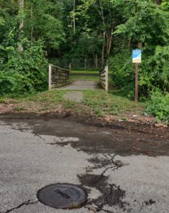
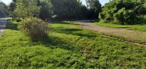
When the Roanoke River Greenway was built, it was not connected to Norwich. Instead a fence separates the residents of Norwich from the Roanoke River Greenway where it is mere feet from the end of Ashlawn Street SW. A post marks a dirt path that people have likely made through accessing the Greenway here. It is a half mile walk, or ride, to the next access point at the current end of the Roanoke River Greenway at Bridge Street SW.
Improving access here could be as easy as removing part of the fence and laying down 10-15 feet of pavement to provide an access point.
Improving access here could also be part of any larger project of repaving in Norwich, if Ashlawn is repaved. Or if sidewalks and gutters were added to the neighborhood, which currently lacks them.
An additional improvement would be striping a crosswalk at the intersection of Ashlawn and Roanoke Ave SW to facilitate a connection between Norwich Park and the Roanoke River Greenway. Creating a good connection there could mean less vehicle traffic for softball games.
A fence prevents access to the Roanoke River Greenway at Ashlawn Street without a walk through grass.
Ashlawn Street lacks a sidewalk and ends at the Roanoke River Greenway.
West End/Hurt Park Access Improvement
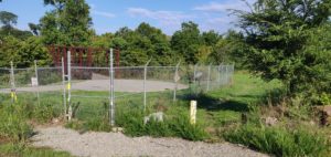
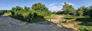
At the end of 17th Street SW there is a gate and a dirt patch that turns to mud when there is rain. This could provide an access point for the West End and Hurt Park to the Roanoke River Greenway.
Aside from the dirt/mud pit, this access point is not ideal. To get to it you have to cross a railroad track once if coming from the west and three times if coming from the east. A more direct path through some of the industrial land along Cleveland Avenue SW could help improve access from the West End and Hurt Park.
The closest alternative access point is at Memorial Bridge. From any place west of 16th Street SW, this is likely to be the closest access point to the Roanoke River Greenway. From the intersection of 18th St SW and Patterson Ave SW, a person would save half a mile if they used this access point rather than the one at Memorial Bridge.
Improving access here could be as easy as laying down about 20 feet of paving where there is a mud pit today.
Improving access here could also be part of a larger project to clean up and redevelop the current industrial uses along Cleveland Ave, particularly if a connection could be made to Campbell Ave SW or 16th Street SW.
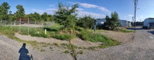
View from 17th Street looking toward Roanoke River Greenway
Large dirt patch seen from Roanoke River Greenway looking toward 17th Street
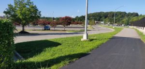
Best Buy Access Improvement
When the Lick Run Greenway crests over I-581 toward Valley View Mall, people are greeted by a sturdy fence that runs along the southwestern edge of the Best Buy parking lot. Eventually that fence ends and the parking lot opens up, but people biking or walking on the Greenway have to continue another thousand feet or so to the signalized intersection to turn into the parking lot.
A ramp and about 5-10 feet of paving could let people access the parking lot without having to deal with the signalized intersection. That would be a great improvement as traffic is heavy at the intersection, making it an uncomfortable place to cross. There is bike parking by the Target and a ramp would ideally be placed to guide people to that bike parking without too much riding through the parking lot.
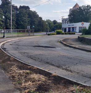
Gilmore/Patton Access Improvements
At Wells Ave SE, the Lick Run Greenway starts to become a real trail. Unfortunately for the people who live along Gilmore Ave NE and Patton Ave NE, there is no ramp along 2nd St SE that gives them access to the Lick Run Greenway.
It is possible to cut through the parking lot of the Anstey Hodge Advertising Group and access the Lick Run Greenway without getting off your bike, or scooter, or wheelchair, or other mobility device. But, cutting through a parking lot is not an ideal solution and does not recognize that people deserve a public right of way to a public space.
For an area that has suffered so much due to transportation projects designed to tear up the community of historic Gainsboro, the least that can be done is to put a curb ramp and about 3-5 feet of trail so that people can access the trail without using the parking lot.
Solid curb at Gilmer Ave
Disturbed plants where people might be accessing trail through parking lot
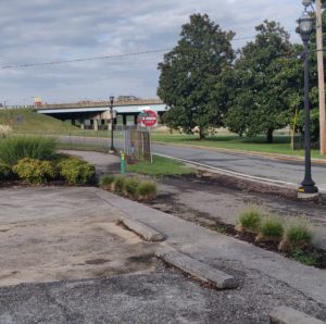
Norris Dr NW Access Improvement
At Norris Drive NW the Lick Run Greenway is accessible from the cul-de-sac end of Norris Drive NW. For residents of Northwest Roanoke who are on the south side of Lick Run the next closest access to the Lick Run Greenway is at Brown-Robertson Park along 10th Street about a mile away. This is access point is the furthest western access point on the south side of I-581. For all these reasons, this should be an important access point as it has the potential to serve a large community in Northwest Roanoke who have no closer access point.
On either side of the bridge over Lick Run at this access point is a mix of gravel, dirt, and vegetation. When it rains, this area can get muddy and stay muddy. There is also the possibility of flooding, which is not exactly uncommon in Roanoke. Improving this access point is straightforward. It would require a paved path on either side of the existing bridge to provide a more consistent surface. My guess is that it would be 20 to 30 feet of path in total. It is possible that some stormwater management would add to the cost and complication of an improvement here, but that is only based on seeing pooled water in the cul-de-sac.
The area to the west of this access point appears to have a complicated development history and the City of Roanoke should improve this access point rather than wait for potential development to provide another access point for Northwest Roanoke or to improve this access point.
I don’t know if the potential for development has prevented Roanoke from investing in this area, but there are some oddities in the neighborhood in anticipation of some development. Andrews Road NW is incredibly wide, probably wide enough for six lanes of traffic or more. It seems likely that some of that width could be used to create a cycle track that connects this Lick Run Greenway access point to Kennedy Park, which has an extensive pathway system. Creating a connection there could also be as easy as adding wayfinding so that more people are aware that the Lick Run Greenway can be found here.