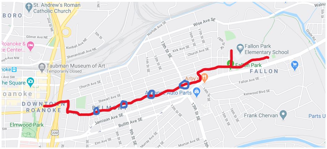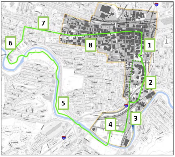
In 2017, the Roanoke Planning Commission voted unanimously to adopt a Downtown Plan that included a vision for a Downtown Roanoke Urban Loop (DRUL). I see 8 sections that the city should think about for the bringing the DRUL vision to life.
- Downtown through Elmwood Park
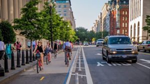
The 2017 plan says that the DRUL will incorporate the existing greenway path through the core of Downtown. The city should strongly consider making some changes to the existing greenway path to make the DRUL the type of project that will be useful for bicycling and promote a strong core. The biggest problem that the city should consider is that Market Street is a one-way street that allows traffic to only travel south. To create a loop that can be traveled either way, the city would need to make Market Street two-way for bicycles or find an alternate route. There’s probably enough space for a contraflow bike lane to be striped on Market Street, but it is also a historic street with brick pavement so the city may want to consider other ways through signage or paint to show that it is a two-way street for bikes. The other issue that deserves immediate attention is the intersection of Elm and Williamson, where there is no pedestrian push-button aligned with the crossing of Elm that is a part of the DRUL. If a push-button is going to be required for this crossing then it should be aligned with the crossing that people are expected to do regularly.
- Williamson Road Protected Bike Lane
The Protected Bike Lane on Williamson Road is mostly nice. It’s a surprising facility and likely needs little attention. As is common with most bike facilities, the issues that do exist are most prominent at intersections. At the entrance to the Carillion Hospital parking garage, it could be helpful to have a conflict area marking with green pavement. At Ablemarle, the pavement is rough and markings are sparse. There is an entrance to a parking lot that creates a long-unprotected space that may lead some to be uncomfortably pulling up to the intersection. I think that may be the only entrance to the parking lot, but there could be an added curb near the intersection to protect bicyclists waiting at the intersection.
- Jefferson Road
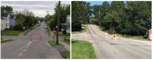
This is probably the most difficult section as there is no clear transition from Williamson Road to Jefferson Road, there is limited space on Jefferson Road, and recent investments do not seem to have taken into account the idea of the DRUL. There’s really no solution that doesn’t involve taking a travel lane in order to make bike lanes, a cycletrack, or expand a sidewalk into a full-fledged trail; or rebuilding the bridge over the railroad tracks in order to expand one or both sidewalks. One creative solution could be to consider an at-grade crossing of the railroad tracks and then building a trail that parallels the railroad track under Jefferson Street. Another alternative would be to avoid this area and instead connect to the Roanoke River Greenway by using Walnut Ave, which has its own issues with inadequate bike lanes, but is generally lower speed and traffic volume. No matter what, this is probably the hardest part of the proposed DRUL to create.
- River’s Edge
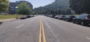
The proposed 2017 DRUL goes east-west on Reserve Ave SW before passing through River’s Edge Park. Reserve Ave SW is currently a four-lane road with parking on both sides. There are large sidewalks and it is possible that the proposed DRUL contemplates using those sidewalks as paths. I have no idea why Reserve Ave SW is a four-lane road. It receives ~7,600 vehicles per day, much less than other two-lane roads in Roanoke. I suspect that the road is extra large to accommodate buses during large youth sporting events, but that means that most of the time there are no bike facilities and a very long crossing distance for pedestrians. There’s a lot of space to do something, anything, that makes for a good DRUL experience.
- Roanoke River Greenway
The Roanoke River Greenway is great. Personally, I wouldn’t be against Wiley Drive SW being closed to cars to create a larger greenway, but as it is the greenway is great. The biggest issue is that there is a high risk of flooding for the low bridge near Smith Park. Long-term, that bridge should be raised to make flooding less likely and ensure that the RRG is usable more days of the year.
- 13th Street
Thirteenth Street, also known – for now- as Lee Highway for part of the contemplated DRUL is mostly fine as is. It has bike lanes on both sides of the street, they’re marked in a way that meets generally observed standards for bike lanes, they could be swept more, but mostly work fine for people who are comfortable bicycling. A few intersections have large exposed areas and are built for fast right hand turns, but nothing is a dealbreaker for an average bicyclist. The city could look at a protected cycletrack for this corridor, probably on the northwest side of the street to minimize problematic turns, and if the city did that it could be continued all the way to the Grandin commercial area to create a more comfortable experience for most bicyclists. I think that might be a good improvement, but it wouldn’t be easy and the street has recently been redesigned so it’s unlikely to be part of the initial DRUL.
- Campbell and/or Patterson Ave until 5th Street SW
The transition from 13th Street to downtown is probably the second hardest part of making a safe, comfortable, and attractive DRUL. I see a handful of approaches that are worth considering, but all have some issues:
- Commit to Campbell Ave – take parking off of Campbell Ave and add bike lanes to both sides of the road. Parking can likely be preserved on one side after 6th Street, but to do it right parking needs to be removed from at least one side of the road. Committing to Campbell Ave also means that bicyclists will be expected to take the left turn at 7th Street, which is not great.
- Split bike lanes onto Campbell and Patterson – this probably still would take some parking, but by having west bound bike traffic on Patterson Ave SW the left turn at 7th Street could be avoided and there would be more room for bike lanes. The parking on Campbell Ave between 13th and 10th could also likely be preserved. From 6th Street on, the issues are the same as committing to Campbell Ave.
- Commit to Patterson Ave – this has the benefit of extending the DRUL through more of the West End and might work better with a cycletrack on 13th If parking was removed from the north side of Patterson, there might be room for a cycletrack on Patterson from 13th to 7th. Things get much more complicated east of 7th. If normal bike lanes were used on Patterson it would create a very weird bike lane through a large uncontrolled intersection (which based on personal experience does not feel safe). A cycletrack extending past 7th would likely mean at least a partial redesign of the intersection to combine the left turn and through lane going east. Ending the cycletrack at 7th could mean rerouting bicyclists onto 7th and then onto Salem Ave SW or Norfolk Ave SW. That might be less intuitive, but also might put bicyclists on a lower traffic street if the city isn’t otherwise putting bike lanes downtown.
- 5th Street SW to Downtown
From 5th Street to Downtown, it feels unlikely that the city will remove parking to stripe bike lanes on Campbell Ave. It also seems unlikely that the city will remove parking to stripe bike lanes on Salem Ave. The best candidates for bike lanes, or other bike facilities to go from 5th Street SW to downtown (defined by me as the City Market) are Luck Ave SW or Norfolk Ave SW. Both are similar in that they are low-traffic, may be too narrow for full bike lanes or a cycletrack, and have sections that are currently one-way that would prevent their full utility as part of the DRUL. None of those issues are too concerning and could be fixed at relatively low cost with signage and painting advisory bike lanes or sharrows where widths are narrow.